| < Previous page | Next page > |
Upstream-Downstream RoutingUpstream-Downstream Aggregation (Routing)
Tool Description: Any NetMap channel reach attribute can be aggregated or routed (length weighted average or summed) either upstream or downstream of every channel segment, revealing patterns at any spatial scale defined by the channel network. For example, a user can calculate the cumulative average, sum or length of fish habitats upstream (or downstream) of any point in the network For example, the sum of values above any point in the stream, as illustrated in Figure 1, is 2.0, and the sum of values looking downstream from the same point is 1.6. Thus "upstream" refers to all the values of a particular attribute, such as habitat potential, summed or averaged upstream of a stream segment of interest. A user can define these attributes above every single road crossing (the latter is a stand-alone tools in the Road Analysis Module).
Data Type: Line (stream layer)
Field Name: UpLength; Common Name: Cumulative Downstream Length
Field Name: UpMean; Common Name: Cumulative Downstream Mean
Field Name: UpSum; Common Name: Cumulative Downstream Sum
Units: variable
NetMap Module/Tool: Analysis Tools/Downstream Aggregation (also located in the Road Analysis Module for road specific applications and in the Aquatic Habitat Module/Upstream Habitat)
Model Description:
This tool calculates the cumulative upstream (and downstream) properties (e.g., upstream or downstream of every segment in a river network) including the length weighted mean or sum for any NetMap parameter. The point of reference is any reach (looking upstream or downstream); the sum or average is calculated from that point in both upstream and downstream directions (Figure 1). For example, if the point of reference in Figure 1 was a road crossing, then the aveage fish habitat score upstream would be 0.58 and it would be 0.32 downstream. The aggregated upstream habitat quality or length is species specific and is based on the defined fish bearing network. Thus, the upstream length of habitat for coho salmon will likely be less than the upstream distance of habitat associated with resident fish. Use of the tool is shown in Figure 2.
The cumulative upstream habitat length parameter is also used in NetMap’s Road Tools where habitat length upstream of each road crossing can be calculated. The tool interface in NetMap allows for numerous options (Figure 2).
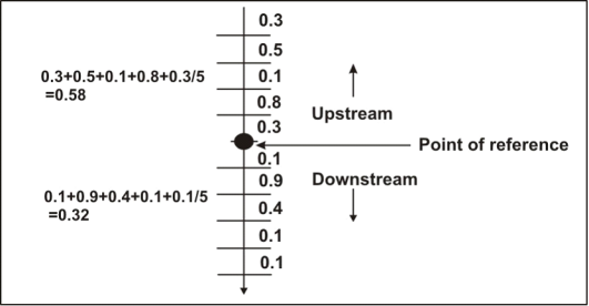 Figure 1. The length-weighted average or sum of any habitat attribute is calculated for each reach (e.g., upstream and downstream from each reach).
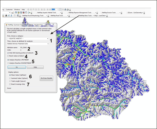 Figure 2. Stream attributes, such as coho salmon intrinsic potential shown in the figure, can be aggregated either downstream or upstream. (1) A user selects an attribute (channel segment) from the drop down lists. The selected attrubte name and units are shown (2). (3) The analysis can be restricted to only the fish bearing portion of the network. (4) Downstream or upstream routing can be interupted at lakes, with the aggregation started up again immediately on the other side of the lake. (5) Upstream or downstream routing is selected. (6) The type of aggregation is selected, including mean value, summed value and total length.
The contents of Upstream-Downstream Routing |