| < Previous page | Next page > |
National Hydrography Data Set (NHD)National Hydrography Data Set (NHD)
The National Hydrography dataset is the “surface water component of the National Map” (http://nhd.usgs.gov/). “The NHD is a digital vector dataset used by geographic information systems (GIS). It contains features such as lakes, ponds, streams, rivers, canals, dams and streamgages. These data are designed to be used in general mapping and in the analysis of surface-water systems.”
The NHD is a cartographic product, digitized from “blue line” 1:100,000 and or 1:24,000 topographic maps, and thus is not derivative from digital elevation models, such as the National Elevation Dataset (NED). For additional information about the latest NHD developments, see
The latest version of the NHD (2012) (NHDplus) represents an integration of the NHD with the Watershed Boundary Dataset (WBD) and the National Elevation Dataset (NED). Since the NHD is not derived from the NED (as is NetMap’s synthetic stream layer), the NHD is “burned” into the NED terrain, and the terrain modified to accommodate any spatial inaccuracies in the NHD with respect to the digital terrain, which can be substantial (see see next section (Figure 1).
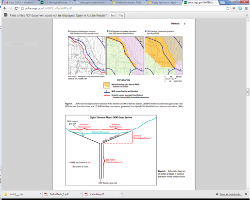 Figure 1. An illustration of how the NHD is “burned” into the NED, thus modifying the NED to accommodate any NHD-terrain mismatches. See also
The NHD is a very important resource and provides a standard stream layer for the nation. Many agencies and others use the NHD, and associated databases, to document the location of streams and rivers, as well as drainage diversions and lakes. Many agencies georeference their stream data to the NHD.
NetMap can add value to the NHD and vice-versa. NetMap is designed specifically to support numerous analytical calculations to aid in resource use and conservation decision making, and thus NetMap's attributes can be cross walked to NHD line segments (for those who wish to maintain NHD stream lines).
The relationship between the NHD/NHDPlus and NetMap is described here. In 2015, NetMap will be producing NHDPlus compliant datasets, starting in the Matanuska-Susitna watershed in southcentral Alaska.
|