| < Previous page | Next page > |
Basin ShapeBasin Shape
Parameter Description: The parameter of basin shape is used to better understand how river network geometry influences the spatial distribution of channel morphology and aquatic habitats.
Data Type: Subbasin
Units: dimensionless
NetMap Module/Tool: Fluvial Processes
Model Description:
Basin shape is defined as mainstem channel length, squared, divided by basin drainage area, producing a dimensionless index (USGS. 1999). A ‘mainstem channel’ is defined by the upstream sequence of tributaries that maintains the largest increase in drainage area as each confluence is encountered. Elongate basins with high shape values (4 - 8) generally contain trellis networks and correspondingly may have a lower potential for confluence effects (Figure 1). Oval-shaped basins that have lower shape values and generally dendritic networks should create a higher potential for confluence effects.
Background:
Network configuration is related to basin shape. Channel configuration (i.e., trellis versus dendritic, Figure 2) should strongly influence channel network patterns and the spatial pattern of predicted confluence effects. For instance, narrow rectilinear-shaped basins that favor trellis networks are predicted to have less opportunity to create geomorphically significant confluences because of the absence of large intersecting tributaries. In contrast, oval- or heart-shaped basins contain dendritic networks and have a greater number of larger intersecting tributaries. Basin shape is used as a watershed parameter in NetMap to describe a basin’s overall potential for tributary confluence effects and hence it is used as an index to sort and rank watersheds according to the propensity for confluences to create habitats (see Sort and Rank tool).
In addition to its role in affecting the spatial distribution of confluences of various size ratios, basin shape may also influence the relative proportions of lower-gradient versus higher-gradient channels in a watershed. For example, with all other things being approximately equal (i.e., lithology, climate, relief, basin size, etc.), rectilinear-shaped watersheds may favor a higher proportion of lower-gradient habitats in contrast to oval-shaped basins that may favor a higher proportion of higher-gradient habitats (Figure 3). This may occur because of the differences in the distribution of stream sizes between the two basin shapes. In general, channel slope decreases with increasing basin size or discharge (Leopold et al. 1964). In rectilinear-shaped basins there are many small streams with small drainage areas (and hence higher gradient) and only a single large trunk stream with larger drainage areas that should have relatively lower gradients. In contrast, the oval-shaped basin has more intermediate-sized streams and basins (and hence intermediate gradients) and consequently should have a relatively lower proportion of its fish-bearing channel system in lower gradient environments.
A preliminary example of the potential effect of basin shape on proportion of low gradient habitats is shown for HUC 6th watersheds in eastern Washington. The data show considerable scatter indicating the multifarious controls that govern long profiles of river or the distribution of profiles in a network, including lithology, structure, glaciation, history of erosion, and network configuration, etc. (Figure 3-109). As mentioned above, the pattern should be most evident in cross-basin comparisons where “everything else is approximately equal”. It is unlikely to find a suitable population of watersheds that have similar physiography where all the things that might control river profiles are equal. Nevertheless and despite the scatter, the data appear to show a rising envelope of an effect where increasing shape factor (indicating rectilinear basins) is related to increasing proportion of low gradient (< 2%) channels. More study is needed to elucidate the effect of basin shape on various riverine attributes, including the proportion of different channel gradients
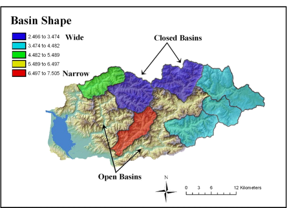 Figure 1. NetMap calculated basin shape only for “closed” basins, defined as basins with only one outlet downstream and no inlets. Open basins with upstream inlets are not classified by shape.
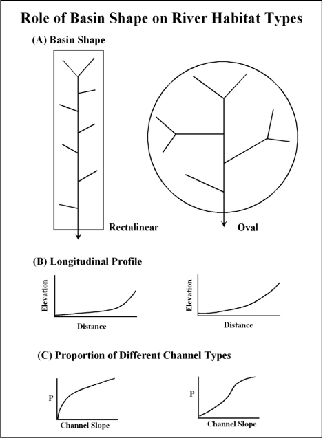 Figure 2. One possible consequence of basin shape is its effect on the distribution of channels of different gradients and hence different types. Narrow, rectilinear-shaped basins could theoretically produce a higher proportion of low gradient channels compared to oval shape basins containing dendritic networks, all other things being approximately equal.
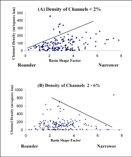 Figure 3. Data obtained from 174 6th-HUC watersheds in eastern Washington are used to make preliminary evaluations of the effect of basin shape on proportion of low-gradient habitats in watersheds. No attempt was made to sort or classify watersheds into similar groups. The data shows considerable scatter probably reflecting the multiple and unknown controls (in this dataset) on river network profiles. Nevertheless, the data appear to indicate an envelope of an effect whereby the basins with the highest proportion of low-gradient habitats tend to be narrower (A). Additional analysis is needed to further test this hypothesis.
|