| < Previous page | Next page > |
Segment InformationSEGMENT ATTRIBUTE INFORMATION TOOL
NetMap Module/Tool: Analysis Tools/Query Database
Model Description:
This tool allows a user to quickly search for specific attributes of any individual stream segment.
Use:
The segment attribute information tool is designed to enhance access to stream reach attributes. It is useful in the office but also in the field using laptops or field computers. The user selects a reach of interest with the pointer tool and a window displays all relevant information for that reach (Figure 1); the stream reach ID is provided. Moving the cursor along the channel network will quickly refresh the data fields in the attribute window. The cursor pointer can be lost if the user engages other Arc functions, such as enlarging the image. The cursor tool can be reengaged by selecting the “click to recover tool”.
The user can change the attribute list and there are six domains of segment attributes (Figure 1) including: 1) channel/valley morphology, 2) LWD [large woody debris], debris flow, and confluence effects 3) habitat indices, 4) hillslope attributes (such as vegetation age, fire risk, burn severity, etc.), 5) erosion and sedimentation, and 6) erosion and sedimentation, adjusted (Figure 1).
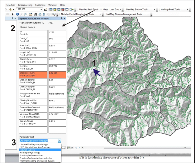 Figure 1. NetMap’s Segment Attribute Information tool allows a user quick access to all relevant parameters within individual channel segments. The user points the cursor at the channel segment of interest (1) and the data screen indicates numerous parameter values for that segment (2), including the reach ID, drainage area, length, and elevation. Other attribute lists are available (3). The pointer tool can be recovered if it is lost during the course of other activities (not shown).
|