| < Previous page | Next page > |
Parameter NestingParameter Nesting (Channel Classification)
Parameter Description: Parameter Nesting creates channel classes that extend to the limits of the channel network (e.g., no segments unclassified) and to ensure that there are no gaps in the classification (e.g., no unclassified
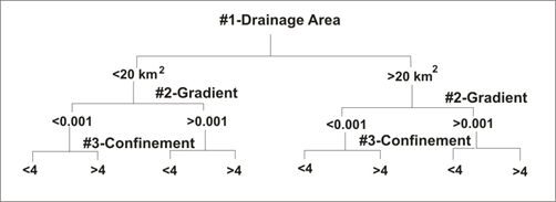
channels). Parameter Nesting, that creates non overlapping channel class categories, defines a number of classes by: N = CP where N is the number of channel classes, C is the number of numeric categories per classification
parameter (continuous without gaps) and P is the number of geomorphic parameters. The number of class types increases with an increasing number of parameters and numeric categories. For example, three parameters and two categories per parameter create eight class types. Increasing the categories to three increases the total number of class types to 27, and so on. To create a reasonable number of channel classification types, a C = 2 and a P = 3 are used to create a maximum of eight channel classes.
Data Type: Line (stream layer)
Arc Field Name: Chclass; Common name: Parameter Nesting Channel Classification
Units: Categories
NetMap Module/Tool: Fluvial Processes/Channel Classification/Parameter Nesting
Model Description:
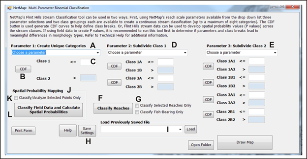 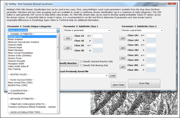 Figure 1. (A, D, E) Select attributes. (C) Set values. (B) Use CDF tool to help create data breaks. (L) This is a custom tool component that requires field data pre-processing by TerrainWorks, contact us; to see how it was used in channel and biotic classification for the US Fish and Wildlife Service in Kansas, see here. (K) Use only a selection of field data. (F) Run classification. (G) Limit classification. (H) Save settings. (I) Load saved settings.
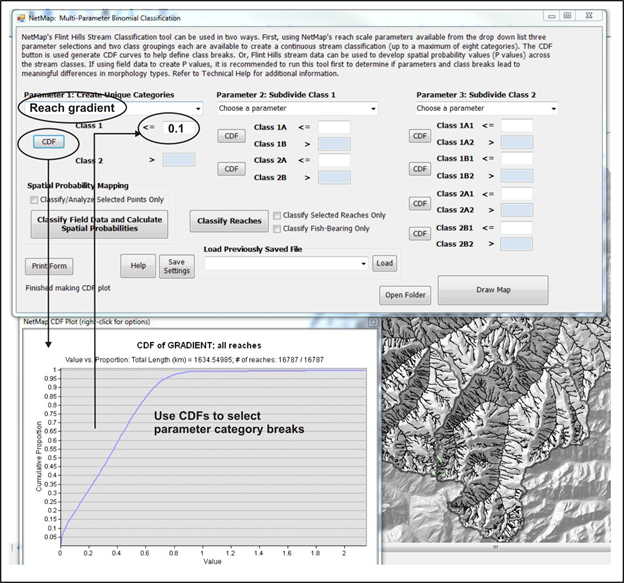 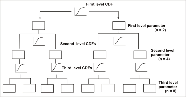 Figure 2. The CDF module in the Parameter Nesting interface aids in setting class breaks.
Using the Parameter Nesting interface in NetMap (Figure 17), an analyst selects from a drop down list of available parameters (Table 2) at each of the three parameter levels (Figure 18). Although geomorphic principles can be used to define category
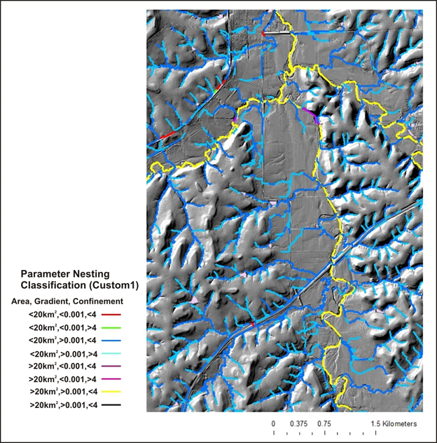
breaks in the Parameter Nesting, viewing cumulative distribution plots of parameters is recommended to define category breaks (Figure 19); a CDF tool is included in the classification interface. Parameter category breaks can be chosen where there is an abrupt change in slope of the CDF at each parameter level. Category breaks at each parameter level must be continuous; there are no gaps in the continuous data series. For example, two drainage area categories (for all channels greater than or equal to 1 km2) might be 1km2 to 10 km2 and >10 km2 to 2000 km2 (the maximum basin area). Or a parameter of channel confinement that ranges from 1 to 10 might have categories of 1 to 4 and 4 to 6.
  Background
Channel size and gradient are generally correlated (narrow channels tend to be steeper) (Leopold et al. 1964) so that gradient alone provides a useful measure for delineating channel types. Common channel types include bedrock–boulder cascade, boulder-cobble step pool, meandering pool and riffle, and braided (Figure 5). For example, meandering pool and riffle channels are often located in channels less than 2% gradient. Boulder and cobble floored, step pool channels generally range in gradient from 2 to 4%, and cascade channels are often in excess of 4% (Grant 1990).
 Figure 5. Estimates of channel gradient, valley confinement, and wood accumulations can be used to infer different channel types that are important to aquatic habitats. NetMap creates maps of channel gradients (Figure 6, A); the user can infer channel types using existing stream classification systems (e.g., Montgomery and Buffington 1997, Rosgen 1995) or based on site-specific field observations (Figure 6, B). Regionally specific channel classification systems can also be used, for example in southeast Alaska (Paustian 1992). Inferring substrate sizes is more difficult because of confounding factors that include lithology, wood accumulations, and disturbance history. Field recognizance (or the use of other databases) is recommended when linking particular channel gradient classes with substrate sizes to the overall environmental context of the channel (i.e., confinement, wood accumulations, and bedrock controls, etc.).
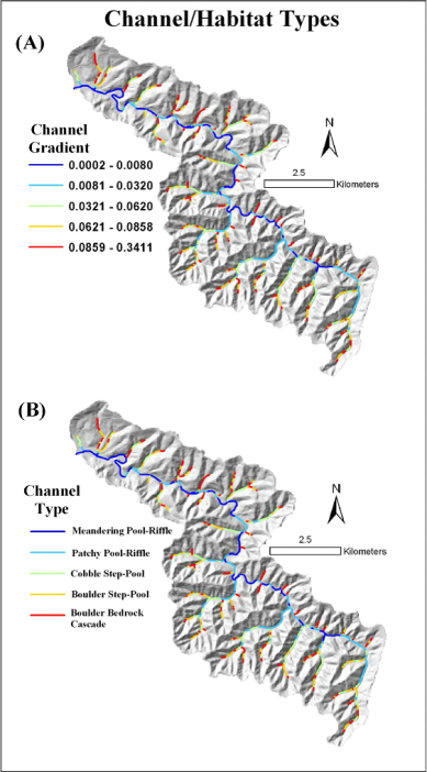 Figure 6. Channel gradient (A) can be a good proxy for different channel types (B), the relationship here shown in a 5th-order basin in the Oregon Coast Range. Other information such as wood accumulation types, valley confinement, near-stream topographic roughness, and erosion potential should also be used to delineate channel types. Use of aerial photography and field surveys is recommended.
|