| < Previous page | Next page > |
Convert to Sediment YieldSediment Yield (Conversion of GEP)
Parameter Description: NetMap’s Generic Erosion Potential (GEP) can be converted to sediment field (t/km2/yr) based on a given a basin mean annual sediment yield.
Data Type: Line (stream layer)
Field Name: SEDYLD_GRID; Common Name: Sediment Supply Grid
Field Name: SED; Common Name: Local Sediment Supply
Field Name: SED_CUM; Common Name: Cumulative Sediment Supply
Units: (t/km2/yr, metric)
NetMap Module/Tool: Erosion
Model Description:
In NetMap, the parameter Generic Erosion Potential provides an index of erosion potential based on slope steepness and slope convergence (Figures 1 and 2). The index addresses erosion processes that are affected by concentrated surface and subsurface flow of water such as shallow failure, debris flow and gully, and surface erosion (although NetMap uses the WEPP model for surface erosion).
A basin mean annual sediment yield is distributed spatially across the basin (grid cells) based on the range and distribution of GEP values. Higher values of GEP have higher sediment yields and lower values of GEP have lower sediment yield values). All GEP based sediment yields are summed at the scale of individual channel segments, and aggregated downstream (t/km2/yr). The model requires that the downstream most area weighted sediment yield value (in the channel) equal the basin average sediment yield.
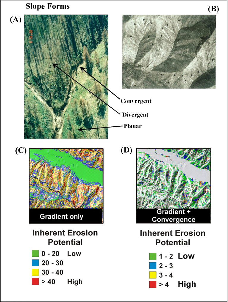 Figure 1. Steep, convergent areas in many landscapes are prone to various forms of erosion including (A) gullying in semi-arid areas, particularly following fires and (B) shallow failures in humid landscapes. Hillslopes can be categorized into (A) convergent, divergent, and planar forms. Slope gradient alone (C) can be used as an approximate indicator of erosion potential since all forms of erosion are strongly governed by slope. A more accurate predictor of erosion potential is slope combined with a measure of topographic convergence to create an intrinsic index of erosion potential (D). NetMap’s GEP index that uses both slope and convergence provides a useful screening of erosion potential across large areas (Figure 2).
Tool Use
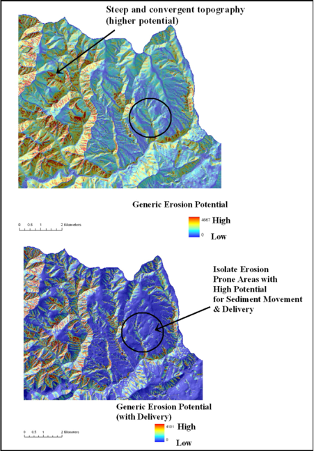 Figure 2. (Top) The NetMap parameter of Generic Erosion Potential (GEP) identifies steep and convergent areas providing a relativistic ranking of erosion potential targeting shallow landslides, debris flows and surface erosion and gullying. (Bottom) GEP is adjusted according to its potential for sediment delivery to streams; this applies only to mass wasting processes and it does not apply to surface erosion sediment delivery.
Although GEP provides an index for evaluating the spatial variability in erosion potential, it is useful to express erosion potential in terms of sediment yield, a common measure in the context of basin sediment budgets (Reid and Dunne). Sediment yield is typically expressed in units of tons per unit time per unit area (t/km2/yr). The model works as follows: an analyst provides an estimate of the basin average sediment yield in terms of t/km2/yr (Figure 3). The average sediment yield is then distributed across the basin, based on the range and distribution of GEP values, such that higher values of GEP have higher sediment yield values and lower values of GEP have lower sediment yield values. The conversion of GEP to sediment yields must satisfy the requirement that when the sediment yield values are reported to the channel (via drainage wings) and summed downstream, the sediment yield value assigned to the lowest most channel segment must equal the basin average that was provided. Outputs include: i) a grid of sediment yield values (pixel scale), ii) segment scale yield (t/km2/yr), and iii) a cumulative channel sediment yield, aggregated downstream (t/km2/yr) (Figures 4 through 6). For an example of how GEP and its conversion to sediment yield was applied to the Mad River (TMDL), see: http://www.epa.gov/region9/water/tmdl/mad/GMA-Mad-River-SSA-final-report-Dec2007-no-plates.pdf
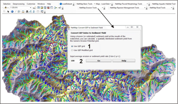 Figure 3. An analyst can convert Generic Erosion Potential values to sediment yields either using the GEP grid, or the GEP_Delivered_Grid (1). An estimate of the basin average sediment yield must be assigned (2) in terms of t/km2/yr. Outputs include a grid of sediment yield values (pixel scale), and four others including segment scale total yield (t/yr), segment scale area weighted yield (t/km2/yr), a cumulative channel sediment yield, aggregated downstream (t/km2/yr) and a total channel sediment yield, aggregated downstream (t/yr). See Figures 4-6.
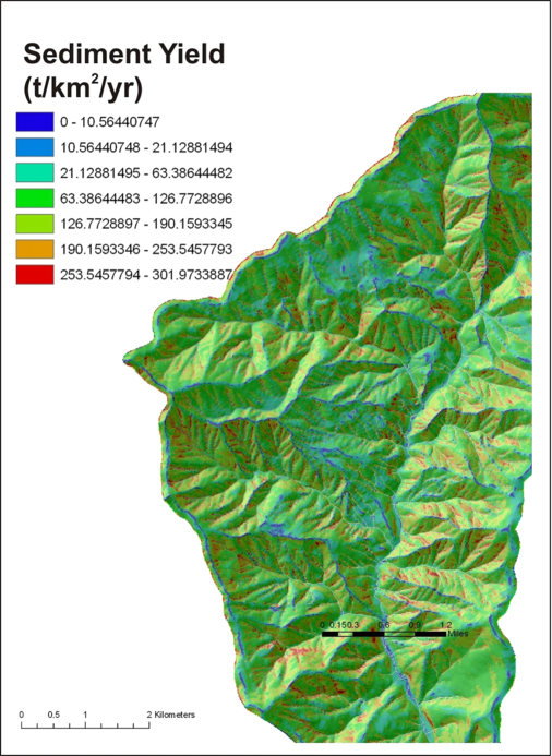 Figure 4. In the conversion of Generic Erosion Potential to sediment yield in NetMap, a grid is created that shows predicted hillslope values of sediment yield that ranges between low values of 10 t/km2/yr (on ridges and very low gradient areas) to values greater than 250 t/km2/yr in steep and convergent areas (basin average = 100 t/km2/yr).
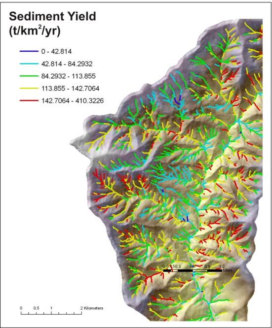 Figure 5. The predicted sediment yield values on the hillslope (Figure 4) is reported to individual channel segments via Drainage Wings. The segment scale, area weighted yields range from under 40 t/km2/yr in low gradient and planar and divergent areas to values greater than 400 t/km2/yr in steep and dissected areas (basin average = 100 t/km2/yr).
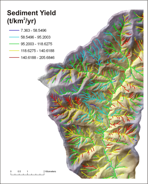 Figure 6. The segment scale sediment yields (Figure 5) are routed downstream, revealing variation in sediment yields at the tributary basin scale, ranging from a low of less than 50 t/km2/yr to values greater than 200 t/km2/yr. The basin average of 100 t/km2/yr was provided by the analyst and the lowest segment in the basin must have that yield.
Technical Background
NetMap’s main erosion functions target steep and convergent areas that are prone to shallow failures and gully erosion. Many landscapes contain other types of erosion processes such as landsliding in inner gorges, deep-seated slumps, and earthflows (Figures 7 and 8). Generic erosion potential (GEP) and shallow landslide models that focus on slope gradient and convergence can apply to surface erosion features on deep-seated landslides and earthflows (GEP does not apply to rotational failures and large scale soil deformation as in earthflows).
NetMap does not predict the location and activity level of individual earthflows that often requires detailed air photo analysis and field studies. For detecting large deep landslides and earthflows, refer to NetMap’s longitudinal plotting tool. Erosion rates and sediment supply to channels by earthflows or other non-GEP types of erosion can be accommodated in NetMap by the use of polygons (earthflows-deep seated slides) to modify GEP values.
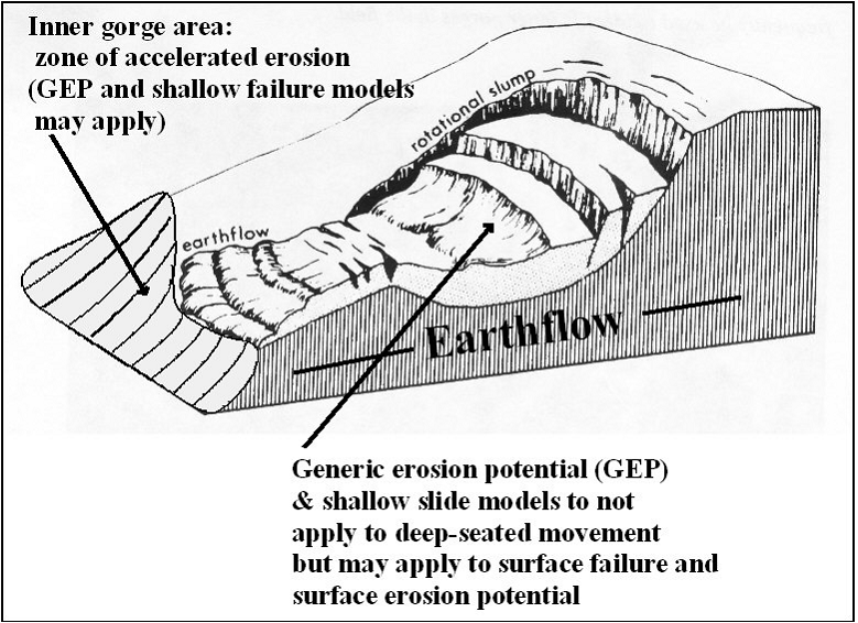 Figure 7. Generic erosion potential and shallow landslide models apply to erosion potential that is driven by hillslope gradient and convergence. GEP may also apply to areas such as inner gorges near streams, to the extent that they are resolvable. GEP-type models do not apply to deeper movement in earthflows and rotational slumps but can apply to surface erosion processes on the slope of deep-seated features, although it can apply to surface forms of erosion on such features.
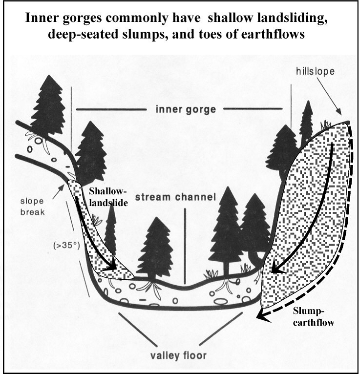 Figure 8. An inner gorge is defined as the lower most portion of a hillslope that is generally steeper than hillslopes above it and may or may not be resolvable on digital elevation models (more likely when using LiDAR, less likely when using 10 m DEMs). Erosion processes within inner gorges can include shallow failures, small rotational slumps, and toes of earthflows. If inner gorges are resolvable, NetMap can account for these processes in the estimation of average annual sediment yields.
|