| < Previous page | Next page > |
Bed Shear Stress/Substrate Size-D50Channel Bed Shear Stress/Substrate Size-D50
Parameter Description: The median (50th percentile) substrate size (D50).
Data Type: Line (stream layer)
Field Name: D50; Substrate; Common Name: Substrate D50; Substrate D50 Classification
Units: mm; classes (sand, pebbles, gravel, cobbles, boulders, based on Wentworth (1922).
NetMap Module/Tool: Fluvial Processes/Hydrualic-Planform Geometry
Model Description:
In NetMap, bed shear stress is calculated by the depth-slope product using channel gradient, flow depth (bankfull, or when bedload is in transit), and water density (1 in Figure 1).
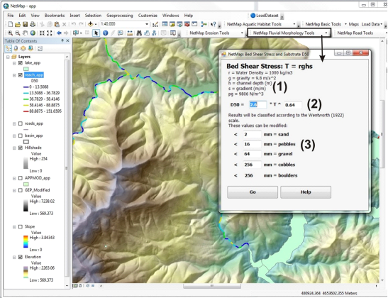 Figure 1. NetMap contains a tool for calculating shear stress (1), median grain size, D50 (2) and substrate size classes (3). A user may wish to alter the regression parameters based on more local data. The default relationship in NetMap between shear stress and substrate D50 is based on a regional regression appropriate for the Pacific Northwest (Buffington et al. 2004).
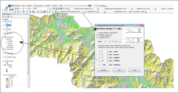 Figure 2. NetMap's tool is used to create classification of substrate sizes ranging from boulder to sand.
The substrate size is predicted based on a relationship between bed shear stress and particle size. This relationship is typically sensitive to specific watershed conditions involving local lithology, stream network geometry and the nature and timing of disturbances in a landscape. Bed shear stress is calculated in NetMap as the depth-slope product (see Fluvial Morphology Module). Particle size values are given for the various substrate name categories (e.g., sand, pebbles, gravel etc.); in NetMap, the Wentworth (1922) scale is used.
The default relationship in NetMap between shear stress and substrate D50 is based on a regional regression appropriate for the Pacific Northwest (Buffington et al. 2004). However, there are many departures from this average relationship having to do with specific lithology (bedrock channels in the Oregon Coast Range due to, in part, weak sandstone lithology [Benda and Dunne 1997]) as well as finer grained substrate due to large scale mass wasting disturbances (Miller et al. 2001). It is recommended that users define their own relationship between shear stress and substrate size and modify the relationship in NetMap. If a different form of the equation (than what is in NetMap’s substrate tool) is used, the calculation can occur external to NetMap and the attribute table in FieldGIS modified.
Technical Background:
Channel substrate size (cobbles, gravels, pebbles and so forth) is an important determinant of fish habitat quality and availability (Bisson et al. 1987, Everest et al. 1987). Substrate size, particularly the median diameter (D50), can be used to help characterize intrinsic habitat potential for various fish species (using NetMap’s habitat creator tools).
|