| < Previous page | Next page > |
Mapping Floodplain RastersFloodplain Tool 1.0:
This NetMap tool creates rasters depicting valley surface elevations relative to the channel, using either elevation in meters or increments of bankfull channel depths. The parameter is designed to delineate areas potentially prone to flooding (at varying levels and magnitudes), identify channel floodplain interactions including channel migration areas and avulsion potentia, terraces (of varying elevations), and alluvial (and debris flow) fans.
This tool provides greater detail about elevation variation compared to NetMap's Tool 1.0 that maps valley floors in increments of bankfull depths using polgons. Delineating floodplains and other valley floor landforms in NetMap can be done for all channels in a watershed at once. However, be aware that during delineation, an analyst must decide whether to evaluate (rank) by area, by elevation (tool interface here) or by bankfull depths. (more detail here).
However, in valley floors that are very wide (multi-kilometers) and that contains multiple channels, including distributaries or confluencing and parallel running tributaries, floodplain delineation of all channels at once can produce errors. This is because the model has difficulty determining which floodplain is associated with which channel.
Hence, when delineating floodplains in wide valley floors, it is recommended to use only a single channel (G in Figure 1).
Data Type: Rasters
Field Name: ChEl_datasetID; Common Name: A raster for elevation above the channel.
Field Name: ChDep_datasetID; Common Name: A raster for number of channel depths above the channel.
Units: meters or number of bankfull depths (#)
NetMap Module/Tool: Fluvial Processes/Floodplain Mapping
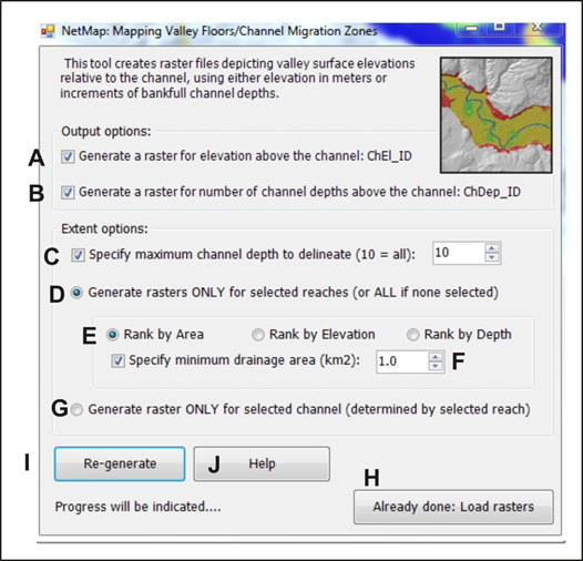 Figure 1. (A) Select to generate valley floor elevations (raster grid) in terms of height above channel in meters. (B) Select to generate valley floor elevations in terms of number of bankfull depths. The default is that both will be generated simultaneously. (C) Specify the maximum number of channel depths to delineate the floodplains, range from one to ten; this option is most relevant when mapping wide valley floors, with the lateral extent of the delineated floodplain increasing with number of bankfull depths. It will also affect the extent of the absolute elevation rasters. (D) Select the reaches to analyze, otherwise all channel segments (and associated valley floors) will be evaluated; running full watersheds may only take a few minutes. (E) For valley floor DEM cells that lie close to two channels (at confluences), it is imporant to consider which channel a valley floor DEM cell will be associated with; this is referred to as "rank by area, "rank by elevation" or "rank by depth", see paragraph above for the description of these options. (F) A minimum channel drainage area for mapping can be selected, set as a default of 1 km2. (G) The analysis can be conducted for individual channels, indicated by selecting an individual reach within a channel (channel is defined as an entire tributary that extends furthest upstream and downstream until it intersects a channel of larger drainage area. (H) A button to load already completed analyses (rasters). (I) Recalculate. (J) Technical Help.
Note that the number of bankfull depths (elevation) chosen controls the lateral extent of the delineated floodplain (C, and see Figures 2 and 3 below).
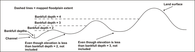 Figure 2. Specifying the number of bankfull depths (elevations) (C in Figure 3) controls the lateral extent of the floodplain that is delineated. Note that interventing high points, if laterally extensive, will limit identification of floodplains as shown in the figure. Hence, a larger number of bankfull depths will capture a larger extent of the floodplain.
Model Description: Channel centerline elevations are estimated from the DEM with channel elevation profiles smoothed by a linear fit over a moving centered window that varies in length (500 m where channel gradients are less than 0.01 to 50 m where channel gradients are greater than 0.20). Each DEM grid cell is assigned an associated channel elevation based on a weighted sum of all channel node elevations within a certain straight-line distance (2500 m) of the DEM cell. Weighting is based on both distance from the channel and on the maximum elevation difference encountered in a straight line between the channel node and the DEM cell; to learn more about how node-based synthetic stream networks are derived in NetMap, go here.
At and near tributary confluences, DEM cells (on floodplains) may be associated with two channels (e.g., the mainsstem or the tributary). The mapped floodplain depends on which channel (mainstem, tributary) takes precedence in the model; the analyst needs to make a decision. If this situation, there are three options: 1) determination by drainage area - floodplain DEM cells are associated with the channel with the largest drainage area, the means that the floodplain will be associated and mapped with the largest channel, e.g., the mainstem; 2) determination by elevation - the channel with the greatest elevation difference is chosen, and since tributaries generally have higher elevations than mainstems, the floodplain DEM cells are associated with the tributary, and 3) determination by number of channel depths, for which the elevation difference (between the channel elevation and valley floor elevation) is smallest, so that if the DEM cell is two channel depths above one channel and one channel depth above another, the smallest, one channel depth is used. This is similar to choosing the channel with the largest drainage area since it will typically have the greater channel depth. If an analyst is only concerned with mapping floodplains along mainstem channels and are not interested in tributary floodplains, then "determination by drainage area" is chosen; if an analyst is interested in tributary floodplains only, and or tributaries and mainstem channels, then "determination by elevation" is chosen (when selecting "determination by elevation" there will be a little spurious noise at the exact confluence points. Figure 1 illustrates this model functionality and model outputs.
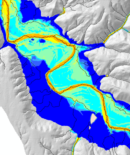 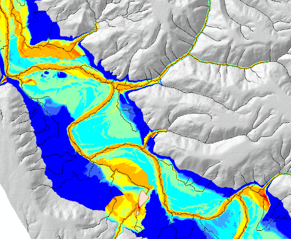 Figure 1. Left panel - delineation by drainage area, note how the tributary floodplains are obscured. Right panel - delineation by elevation, note how the tribuary floodplains are correctly delineated. The determination by elevation is best when seeking to map floodplains for both mainstem and tributary channels.
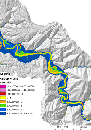 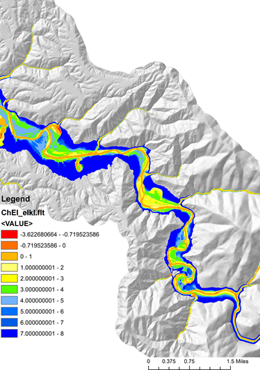 Figure 2. (Left panel) Delineation of floodplains and other valley floor landforms in terms of bankfull depths. (Right panel) Delineation of floodplains and other landforms in terms of absolute elevation. Often, more spatial detail is obtained when delineating floodplains and other landforms by absolute elevations. Both data forms are produced when running NetMap's tool.
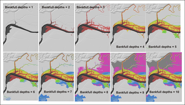 Figure 3. Use of an increasing number of bankfull depths leads to an increase mapped extent of the floodplain (specifying C in Figure 3). Example is from the Matanuska-Susitina watershed in Alaska.
Example Applications.
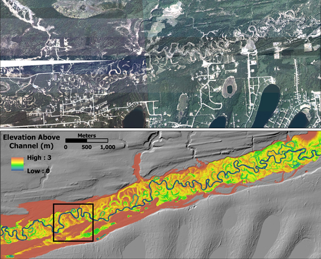 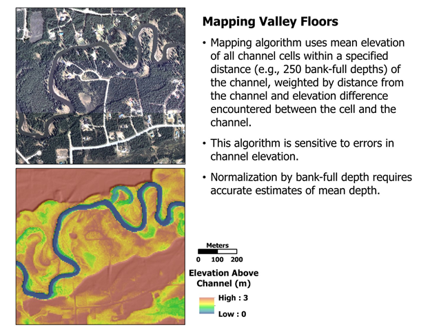 FIgure 4. Mapping valley floor elevations and areas prone to avulsions and migration (e.g., channel migration zones) in the Matanuska-Susitna watershed in southcentral Alaska using NetMap tools.
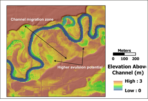 Figure 5. NetMap's valley floor mapping tool is used to identify channel migration zones and areas of higher avulsion potential. 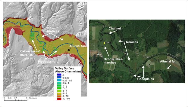 Figure 6. NetMap's valley floor mapping tool, particularly in concert with LiDAR DEMs, can be used to identify oxbow lakes, cutoff meanders, side channels, floodplains, marshes and alluvial fans.
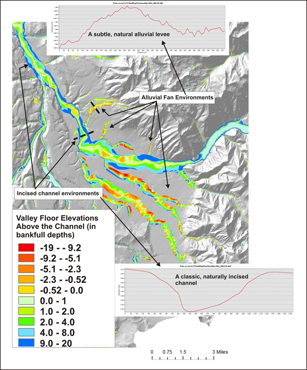 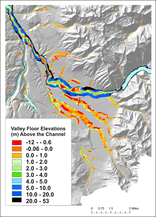 Figure 7. The tool can be used, even with 10 m DEMs, to identify channels on alluvial fans and channels that are incised and thus laterally stable.
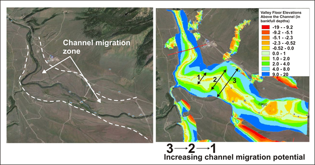 Figure 8. Even using 10 m DEMs, potential channel migration zones can be identified, as illustrated in the Madison River, Montana.
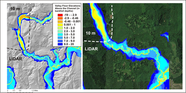 Figure 9. Although there are marked differences between valley floor mapping using LiDAR (2.5 m) versus 10 m DEMs, NetMap's mapping tool can still differentiate attributes of the valley floors, including floodplains, channel migration areas and areas of potential avulsions.
|