| < Previous page | Next page > |
Erosion SignificanceErosion Significance (of headwater streams)
Parameter Description:
Data Type: line (reach attribute)
Field Name: DF_SIG; Common name: Erosion Significance
Units: meters, L/L
NetMap Module/Tool: Erosion/Erosion Significance
Model Description (this tool is not currently in NetMap):
Headwater streams in mountain environments are often prone to channel scouring events such as debris flows and gully erosion. Headwater channels can be significant sources of sediment to mainstem channels because of the large volumes of sediment and woody debris involved in channel scouring events. However, the significance of episodic erosional events declines with the size and sediment yield of the main channel they enter. The sediment significance of headwater tributary basins should depend on 1) the erosion potential of the tributary basin compared to the mainstem basin and 2) the magnitude of sediment pulses (i.e.., debris flows) compared to the sediment pulses likely encountered in the mainstem river. Other factors may include the size composition of introduced sediment (from the tributary) and the presence of large wood.
To estimate the relative erosional significance of tributary basins in NetMap, two parameters are used to create an ‘Erosional Significance’ Index. To create the index, first the ratio of the average erosion potential of the tributary basin to the average erosion potential of the mainstem basin using the Generic Erosion Potential index is calculated. The degree of variability in sediment flux from the headwater tributary (for example the magnitude of debris flows) compared to the degree of variability in sediment flux in the mainstem needs to be considered. For example, field measurements and model simulations (Benda 1994, Benda and Dunne 1997a) indicate debris flows have volumes that range from 2,000 to 4,000 m3 originating from basins of 0.1 to 0.5 km2 that have average erosion rates of 15 to 35 m3 yr-1. The same model simulations show that sediment pulses (compared to average sediment annual sediment yields) in alluvial networks decline dramatically downstream and can range from about 2 to 4 in third- through sixth-order channels with drainage areas up to 200 km2 (Benda 1994) (Figure 1).
NetMap’s erosion significance tool requires that the user estimate (or provide a reasoned guess) at the ratio between the volumetric magnitude of large sediment pulses (such as debris flows or gully erosion) in headwater streams and the tributary basin average annual sediment export volume; values may range from ten to a hundred or more (Figure 2). The user also selects a minimum tributary basin size to perform the analysis on. The results indicate the sedimentological and morphological significance of tributary basins within mainstem channels (Figure 2).
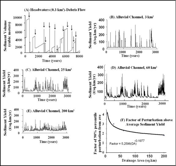 Figure 1. (A) Debris flow sediment volumes (arrows in A) in small first-order headwater basins are larger than the tributary’s mean annual sediment yield by a factor of 50 to 100. (B) In third order basins (3 km2) sediment yield perturbations are approximately 4 times higher than the average sediment yield, and 3, 2.5 and 2 times higher respectively in basins of 25 km2 (C), 60 km2 (D), and 200 km2 (E) (simulation data from the Oregon Coast Range in Benda and Dunne 1997a,b). (F) The difference between the 90th percentile of sediment flux perturbations (positive departures from the average) and the mean sediment yield compared to drainage area yields the function shown.
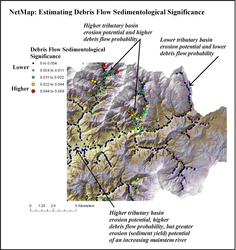 Figure 2. NetMap contains a tool for estimating the sedimentological significance of headwater streams prone to debris flows in the context of larger (alluvial) channels. See discussion above for details.
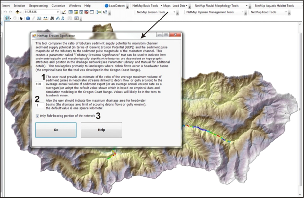 Figure 3. NetMap’s Erosion Significance Tool is most applicable to watersheds in which headwater streams are subject to low frequency, high magnitude erosional events including debris flows, gullying, hyperconcentrated flows, particularly during large storms or following wildfires and certain land use practices (removal of vegetation, road construction). First, a user estimates the ratio between the volumetric magnitude of large sediment pulses (such as debris flows or gully erosion) in headwater streams and the tributary basin average annual sediment export volume (likely between 10 and a hundred or more). The user then selects a minimum basin area threshold for defining tributary basins. The analysis can be applied to the entire network or only to the fish bearing portion (3). See example results in Figure 2.
|