| < Previous page | Next page > |
Channel ConfinementChannel Confinement Classification
Parameter Description: In NetMap, channel confinement is the degree to which channels are limited (or confined) in their ability to move laterally. Confinement can result from bedrock walls (canyons), closely spaced hillslopes, or by entrenchment into a floodplain (channels entrenched into floodplains are difficult to detect using digital elevation models).
Channel confinement is calculated as floodplain width divided by channel width. Floodplain width is calculated using NetMap’s ‘Floodplain Mapping Tool’ (in Fluvial Processes Module) at variable heights above the channel, in numbers (and fractions) of bankfull depths. The default value of floodplain width is calculated at two times bankfull depth.
User-defined classification of channels as CONSTRAINED, UNCONSTRAINED, INDETERMINATE, EXPANDING, or CONTRACTING, based on the VWI values
specified for CONSTRAINED and UNCONSTRAINED Channels. Channel reaches separating upstream CONSTRAINED from downstream UNCONSTRAINED channels are classified as EXPANDING. Channel reaches separating upstream UNCONSTRAINED from downstream CONSTRAINED reaches are classified as CONTRACTING. Reaches with VWI values between CONSTRAINED and UNCONSTRAINED are classified as INDETERMINATE. If an INDETERMINATE reach falls between two reaches of the same class, it is reclassified to match the up and downstream reaches.
Data Type: Line (stream layer)
Field Name: ccon; Common Name: Channel Confinement classes (contrained, unconstrained etc.)
Field Name: valcnstrnt; Common Name: Channel confinement, floodplain width divided by channel width (numeric)
Units: meters/meters, dimensionless; classes (n=5)
NetMap Module/Tool: Fluvial Processes/Channel Confinement
Model Description:
NetMap’s Channel Confinement Tool has two capabilities. First, it calculates valley width divided by channel width (Vw/Cw), with the FieldName = CCon, a stream segment variable. Second, it creates classes of confinement based on user supplied definitions of “constrained” and “unconstrained” channels. The tool uses values of floodplain width predicted by NetMap’s ‘Floodplain Mapping’ tool (‘Fluvial Morphology Module’). The current value of channel width is also used (‘Fluvial Morphology Module/Hydraulic-Planform Geometry’). When a user calculates the classes of confinement, the reach attribute valley width divided by channel width (CCon) is automatically created.
A user indicates the threshold values for Vw/Cw to differentiate constrained from unconstrained channel segments (Figure 1). If the threshold values are not numerically coincident (i.e., constrained <5, unconstrained >10), then intermediate segments will also be defined. [If the values are coincident, then there will be no “intermediate” segments.] The tool will also identify channel segments that fall between constrained and unconstrained classes, and they are referred to as “transition” segments. The transitions segments are classified as either “constrained – unconstrained” or “unconstrained – constrained”. The transitions segments can be used to help understand where large (valley driven) changes in hyphoreic flow are occurring. For example, hyphoreic down-welling can occur in constrained – unconstrained transitions and hyphoreic up-welling can occur in unconstrained – constrained transitions. Valley confinement transition segments can be used in habitat models or habitat disturbance indices.
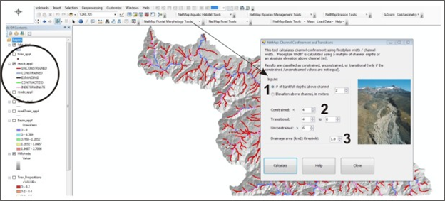 Figure 1. NetMap’s Channel Confinement tool allows a user to specify the definitions of “constrained” and “unconstrained” segments based on the ratio of valley width to channel width or Vw/Cw (1). Valley width can be calculated at various elevations above the channel either in terms of numbers of bankfull depths or in absolute elevation above the channel (refer to ‘Floodplain Mapping Tool’ in the ‘Fluvial Morphology Module’). Transition segments are also identified (constrained-unconstrained, unconstrained-constrained), useful for evaluating potential for hyphoreic exchange and channel disturbance potential (2). The user can limit the extent of the valley morphology classification (3) and thus exclude headwater streams where the predicted Vw/Cw is less accurate. Identification of transition segments is increased when Vw/Cw ratios for constrained and unconstrained (1) are numerically coincident such that no “intermediate” segments are defined.
|