| < Previous page | Next page > |
Stream Segment ScaleRoad Density (stream reach scale)
Parameter Description: Road density (km/km2, mi/mi2) is calculated at the scale of individual stream segments (50 - 200 m) and thus at the scale of individual drainage wings (~0.1 km2). Users can import their own road layer, although most NetMap watershed datasets will come bundled with a road layer.
Data Type: line
Field Name: RdsDensLoc; Common name: Road Density (Reaches)
Field Name: RdDensUp; Common name: Road Density, Aggregated from upstream to any downstrean reach
Field Name: RdDensDown; Common name: Road Density, Aggregated downstream to any upstream reach
Field Name: RdDensL; Common name: Road Density, Segment Left side (looking downstream)
Field Name: RdDensR; Common name: Road Density, Segment Right side (looking downstream)
Units: meters, L/L2, #/L2
NetMap Module/Tool: Roads
Model Description:
In NetMap, the density of roads is calculated at the channel segment scale (20 – 200 m). This is accomplished by measuring the length of roads that pass through the local contributing drainage areas (e.g., drainage wings) of individual channel segments (from both sides of the channel); see Figures 1 and 2. NetMap’s tool also aggregates the segment-based road density calculation downstream, thus yielding an estimate of road density at any spatial scale defined by stream networks (Figures 3 and 4).
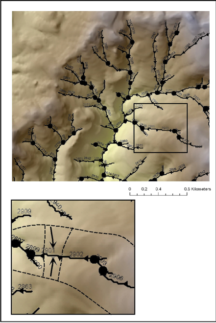 Figure 1. NetMap applies a universal data structure to all of its watershed analyses. This involves organizing river networks into stream segments (with Ids), confluence nodes, and local contributing drainage areas. Hillslope and channel information is routing downstream revealing patterns across multiple scales.
 Figure 2. In NetMap, certain hillslope parameters are aggregated into the nearest and downslope stream channel segment (1) so that they can be used with other NetMap tools. NetMap determines the contributing hillslope area that drains into channel segments (on both sides of channels) that range in length from 20 to 200 m (2). The algorithm then determines the amount of road length that intersects those contributing areas and calculates a channel segment-based road density (km km-2) (3). NetMap also aggregates segment-based values downstream throughout a river network (which can be viewed either as the aggregated value from upstream or downstream), yielding drainage area weighted values for road density.
 Figure 3. NetMap’s Road Density tool is used to calculate the road density within contributing areas of individual channel segments (drainage wings). As illustrated above, road density per channel segment shows significant variability (only the fish bearing network is shown), from zero to more than 300 km km-2. In the tool, (1) a user selects the units (km/km2 or mi/mi2). (2) The routed values (see below) can be interupted at lakes or reservoirs. (3) When routing or aggregating, a user selects either all values upstream of any channel segment (e.g., "road density upstream") or aggregating all values downstream from any segment (e.g., "road density downstream)." (4) Display results for the entire stream network or for fish bearing network only.
For additional informtation on road density and using NetMap's road tools, see also http://www.netmaptools.org/Pages/Clearwater_NetMap_final.pdf.
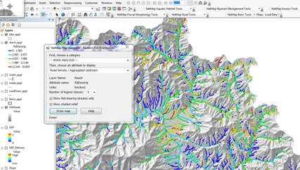 Figure 4. Results from routing or aggregating channel segment scale road drainage values, the upstream aggregated value reported in every individual channel segment. For example, road density is low to zero in headwaters with minimal roads but increases downstream where there are more numerous roads. Road density could also decrease downstream by incorporating larger areas with more diverse road networks.
|