| < Previous page | Next page > |
Mapping Floodplains/Valley FloorsFloodplain Tool 1.0:
Parameter Description: This NetMap tool creates polygons and a channel readh attribute depicting valley surface elevations relative to the channel, using increments of bankfull channel depths or in absolute elevation. The parameter is designed to delineate areas potentially prone to flooding (at varying levels and magnitudes), identify channel floodplain interactions including channel migration areas and avulsion potential, terraces (of varying elevations) and alluvial (and debris flow) fans.
For additional information about how NetMap is used to map floodplains, see: http://www.hydrol-earth-syst-sci.net/15/2995/2011/ .
Data Type: Polygons
Polygon Field Name: vw_(# of bankfull depths) or vw_(absolute elevation, meters); Common Name: A polygon for elevation in multiple of bankfull depths above the channel.
Reach Attribute Field Name: Reach FP_Width (absolute elevation, meters).
Units: meters or number of bankfull depths (#)
NetMap Module/Tool: Fluvial Processes/Floodplain Mapping
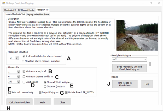 Figure 1. (A) Select mapping protocol, either in multiples of bankfull depths (n = 2 is often considered the active floodplain); (B) set minimum channel drainage area, setting at 1 km2 eliminates headwaters and the program runs faster; (C) a minimum channel width (meters) can also be specified, rather than drainage area; (D) lateral extent of the mapped floodplain can also be limited, either in multiples of channel width or in absolute distance (meters); (F) single channels (ID_) can be selected for mapping (to determine channel ID, use the information tool in ArcMap and click on an individual channel reach, and identify "CHAN_ID"; (G) either floodplain polygons or reach attribute can be selected (default is both); (H) run tool; (I) select existing saved mapped floodplain polygons and load them into ArcMap; (J) roads (requires road layer) located within selected floodplain polygons can be identified.
Model Description: NetMap's polygon floodplain mapping tool uses absolute elevation or multiples of bankfull depth above the channel. To characterize valley-floor surfaces DEM cells were classified according to elevation above the channel. Each cell within a specified radius (1500 m) of a channel is associated to the closest channel cell, with distance to the channel weighted by intervening relief. Valley-floor DEM cells are associated with channels that are closest in Euclidean distance and have the fewest and smallest intervening high points. The elevation difference between each valley floor cell and the associated channel location is normalized by bankfull depth and valley floors are characterized in terms of number of bankfull depths above the channel. This procedure is repeated for every channel segment.
Floodplains typically lie at, or somewhat above, bankfull stage (Dunne and Leopold, 1978). In practice, zones of frequent inundation are defined by an elevation above the channel equivalent to two bankfull depths (Rosgen, 1996, Castro, 1977). To illustrate a wide range of flow inundation-valley topography relations in the Pas River, we delineated surfaces above the DEM-inferred channel using elevation equivalents of one, two, and three bankfull depths.
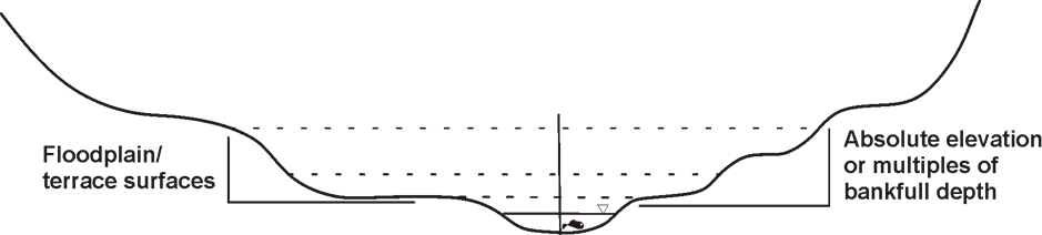 Figure 1. Illustration of ranges of bankfull depths or absolute elevation above the channel elevation.
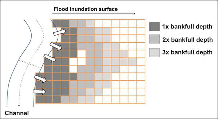 Figure 2. Each cell within a specified radius (for example, 1500 m) of a channel is associated to the closest channel cell, with distance to the channel weighted by intervening relief. Valley-floor DEM cells are associated with channels that are closest in Euclidean distance and have the fewest and smallest intervening high points. The elevation difference between each valley floor cell and the associated channel location is normalized by bankfull depth and valley floors are characterized in terms of number of bankfull depths above the channel. This procedure is repeated for every channel segment.
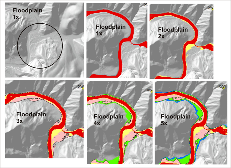 Figure 3. An example in the Oregon Coast Range of mapped floodplain and terrace elevations in multiples of bankfull depths. 1x is generally the bankfull channel; 2x is often the active floodplain; 3x may be a floodplain only inundated during very large floods; 4x and 5x may represent near-stream terraces.
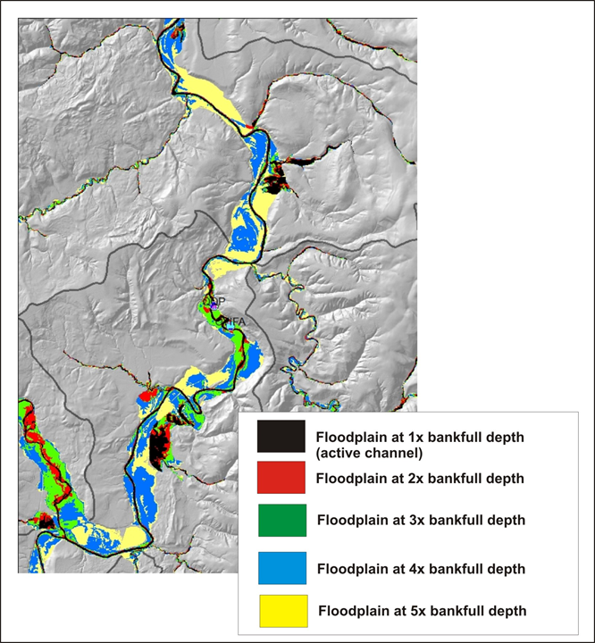 Figure 4. An example of a typical mosaic of floodplain and terraces surfaces mapped by NetMap.
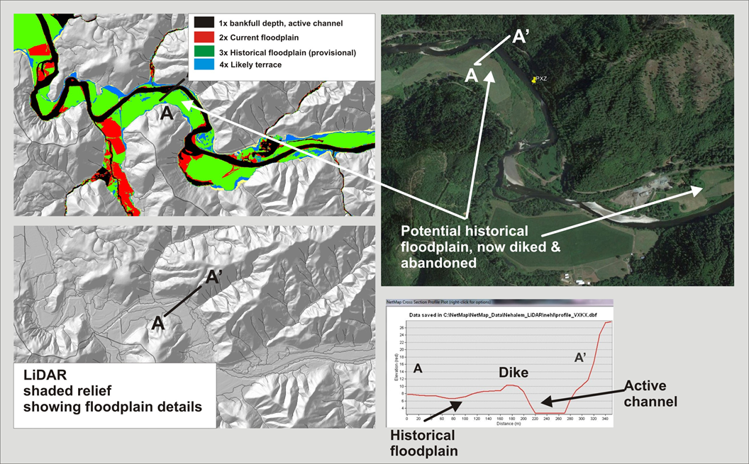 Figure 4. NetMap's floodplain polygons can be used to identify current and historical floodplains, particularly when using LiDAR DEMs.
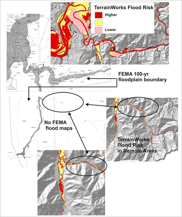 Figure 5. NetMap's floodplain polygons often cover more areas, particularly outside of urban zones, compared to FEMA 100-year floodplains. They also provide more spatial detail, e.g., floodplains less than the 100-year.
|