| < Previous page | Next page > |
3.9 Wood Accumulation TypesWood Accumulation Types (In-stream)
Parameter Description: The types of instream wood accumulation including single pieces, full and partially spanning log jams, scattered pieces, and no wood accumulation (e.g., high energy systems). See also NetMap's in-stream wood recruitment prediction tools.
Data Type: Line (stream layer)
Field Name: LWD_TYPE; Common Name: Wood Accumulation Type
Field Name: PSCATTERED; Common Name: LWD, scattered accumulations_prob
Field Name: PSINGLE; Common Name: LWD, single pieces_prob
Field Name:PSPANNING; Common Name: LWD, spanning and partial jams_prob
Units: Classes (n=4) and probabilities (0-1)
NetMap Module/Tool: Fluvial Processes/Wood Accumulation Types (see also NetMap’s wood recruitment tool [reach and watershed scale])
Model Description:
NetMap contains a tool for estimating the types of wood accumulation in streams. Four wood accumulation types are defined in NetMap based on field measurements: 1) individual spanning logs, 2) spanning and partial stream-spanning jams (30 – 70% of the channel is spanned), 3) scattered accumulations on lateral bars, and 4) no wood accumulation (too high energy streams) (Figure 1).
The model objective is to minimize complexity in order to examine how a few factors (drainage area and slope [stream power], riparian tree height [e.g., log size], and channel width) impose constraints on spatial patterns of different wood accumulation types at the scales of watersheds. For instance, large, channel-spanning logs in small streams tend to stay where they fall. If the channel has sufficient power to transport wood, channel-spanning logs can form. Larger and more powerful channels will favor the formation of partial jams, scattered bar accumulation, or no accumulations at all.
Based on field surveys and observations, different wood accumulation types fall into relatively distinct fields in a plot of drainage area (surrogate for stream size and stream power) against tree height scaled by channel width (Figure 2). The average height of riparian trees is used as a relative measure of log length, since piece sizes should correlate with the height of streamside trees (i.e., tall trees should break into longer pieces than short trees).
In Figure 3, fields for different accumulation types tend to be separated along lines perpendicular to the general log-log trend of the data points (reflecting the correlation between channel width and drainage area). By analyzing the varying density of points associated with each accumulation type the probability of finding a particular accumulation type can be estimated (e.g., Figures 3 and 4). To extend these results to a predictive model, a DEM-derived estimate of drainage area is employed. Channel width is regionally calibrated to drainage area and mean annual precipitation. Site-potential tree height is used as a relative indicator of potential log size and is generally available in open-source digital databases (site class and vegetation maps).
NetMap’s tool requires that the user select an average tree height for an entire basin or inputs a polygon layer or grid of spatially-variable tree heights (Figure 5). Model predictions include the probability of each individual accumulation type (Figure 6) and the dominant wood accumulation type (the one having the highest probability) (Figure 7).
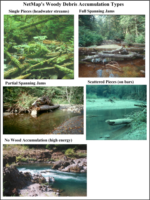 Figure 1. NetMap recognizes four major wood accumulation types. “Single pieces” indicating lack of significant wood transport (i.e., absence of log jams), a condition that typically occurs in headwater channels. “Full spanning” and “partial-spanning jams” are created in larger streams and they catch woody debris that is fluvially mobile (in NetMap, these two categories are combined). “Scattered pieces” occur in wide channels (where channel width > streamside tree height) and logs reside on lateral or mid channel bars. High energy, whitewater-rivers may have little to no wood storage (referred to as “no wood accumulation”).
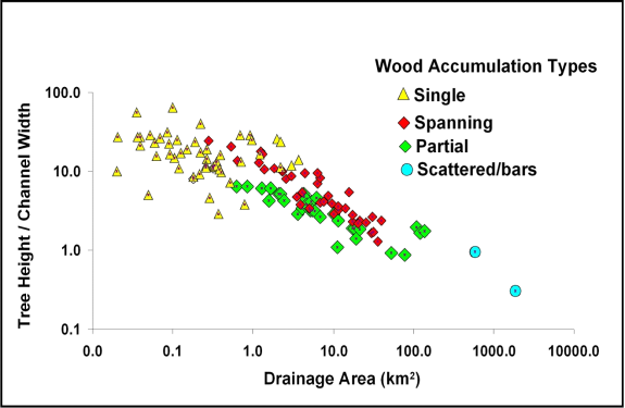 Figure 2. Wood in streams creates various types of accumulations that have implications for riverine ecology. In-stream wood can create different accumulations including jams that mostly or partially span a channel. In small streams, logs may be found in single pieces. In large rivers wood may be scattered laterally on bars and not create jams. In steep whitewater streams, no wood may accumulate. Field data from wood surveys are arrayed according to drainage area (surrogate for stream power), channel width, and tree height (proxy for relative piece length), parameters that are known to influence wood transport. The distribution of the different wood accumulation types is analyzed probabilistically (see Figures 3 and 4). In NetMap, the category of full spanning and partial spanning are combined due to their overlap in the data distribution.
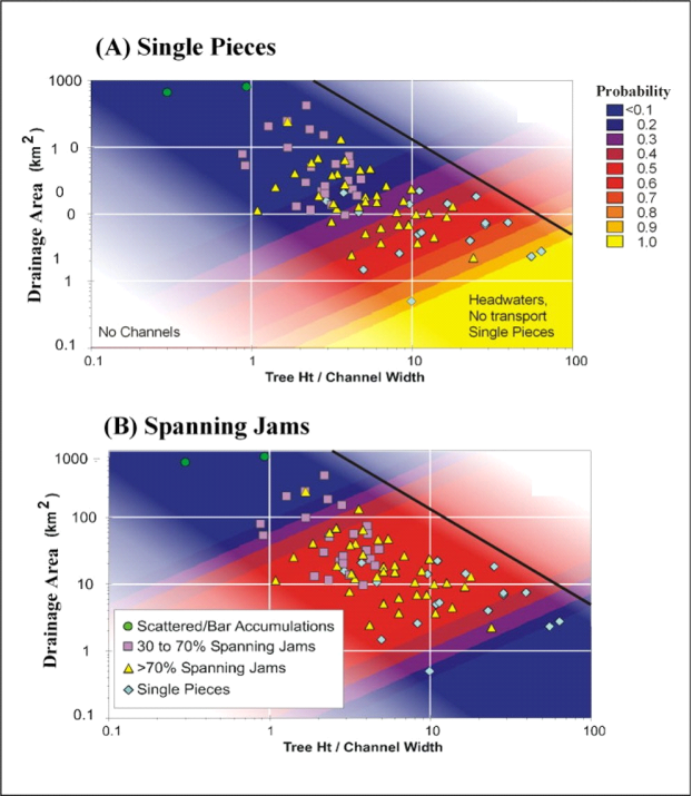 Figure 3. Data on wood accumulations (Figure 1) are used to create relationships that indicate varying probability of different wood accumulation types shown here for (A) single pieces (spanning, non mobile) and (B) spanning jams (> 70% of channel spanned by logs).
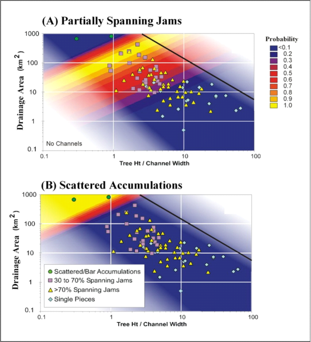 Figure 4. Data on wood accumulations (Figure 1) are used to create relationships indicating varying probability of different wood accumulation types shown here for (A) partially spanning jams (30 – 70% of channel width spanned by logs) and (B) scattered accumulations on bars. Spanning and partial spanning jams are combined. In addition, the field “no wood accumulation” is based on stream power (channel slope multiplied by drainage area).
Tool Use
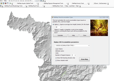 Figure 5. In-stream wood accumulation types are predicted within NetMap based on Pacific Northwest regional data (see Figure 1). The user selects a basin average tree height (1) or imports a shapefile or grid containing variable height trees (2). One can change the tree height and thus the distribution of accumulation types and thus “game” different scenarios.
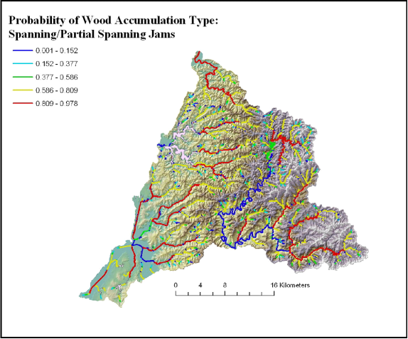 Figure 6. NetMap predicts the probability of different wood accumulation types in streams.
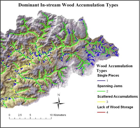 Figure 7. Using the probabilistic relationship for wood accumulations in Figures 3 and 4, the most likely type of wood accumulations are predicted across large river basins.
Technical Background:
The importance of large wood in streams for the development of high quality aquatic (fish) habitat is well recognized (Bisson et al. 1987, Bilby and Bisson 2004). The processes of forest mortality, bank erosion, streamside landsliding, debris flows and wildfires govern the supply of wood to streams (e.g., Murphy and Koski 1989, Benda and Sias 2003). The spatial distribution of different wood recruitment processes within a watershed or across landscapes varies substantially because of the diversity in forest composition and age, topography, stream size, climate and the history of natural and human disturbances (e.g., floods, fires, logging). This in turn will lead to variations in the size of wood entering channels. In addition, the size and stream power of the stream or river will also govern the distribution of pieces in stream channel networks. This information has several practical uses. Under existing watershed conditions, streams may have a lack of wood due to logging, splash damming, and stream cleaning. Predictions of wood accumulation types can help determine what types of fish habitats will form in the future and can be used to help plan stream restoration activities.
|