| < Previous page | Next page > |
Sockeye salmon IPParameter Description: In cooperation with the Chugach National Forest, a provisional sockeye salmon intrinsic potential model was developed and applied to a portion of the Kenai Peninsula.
Data Type: Line (stream layer)
Field Name: IP_Sock; Common Name: Sockeye; intrinsic habitat potential score
Field Name: SockQual; reaches qualifying as potential sockeye habitat with lakes and no gradient barriers
Units: Habitat intrinsic potential score, 0 - 1.
NetMap Module/Tool: Aquatic Habitats
Model Description: The model consists of two components: 1) screening for availability of sockeye river spawning habitat that requires lakes within watersheds connected to streams of a minimum size with no gradient barriers between lakes and the ocean, and 2) application of a set of habitat intrinsic potential preference curves pertaining to: a) distance of individual stream reaches to lakes, b) gravel availability, specifically below lakes, c) channel gradient and d) channel confinement by valleys or existance of floodplains. The flow chart (Figure 1) shows the general model structure.
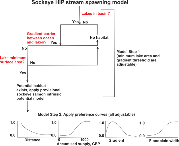 Figure 1. Flowchart of general model structure. Preference curves are idealized.
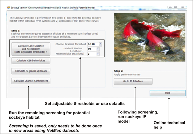 Figures 2. Model interface for conducting step 1, identifying sockeye salmon qualifying stream reaches.
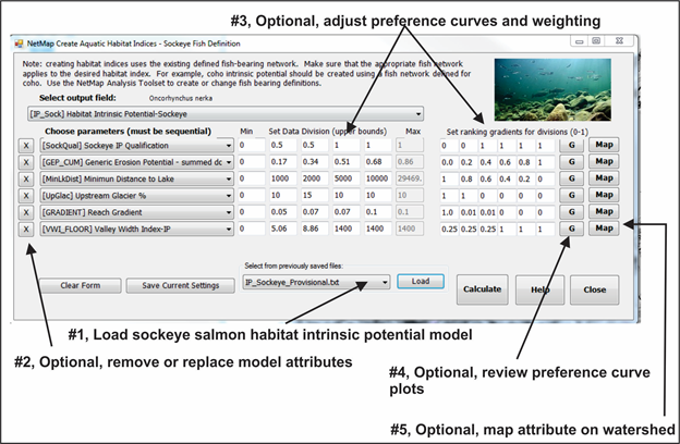 Figure 3. NetMap Intrinsic Potential interface for all species, including the provisional sockeye salmon model.
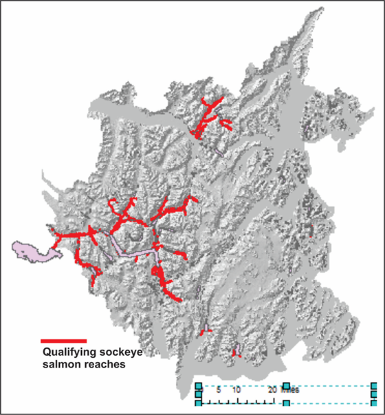 Figure 4. Stream reaches with sockeye stream spawning habitat potential.
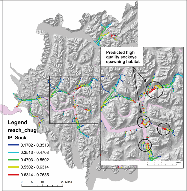 Figure 5. Predicted sockeye salmon habitat intrinsic potential on a portion of the eastern Kenai Peninsula.
Background
Habitat conditions required for sockeye salmon are well known. Sockeye salmon spawn in large rivers and small streams with the co-occurrence of lakes and ponds connected to channel networks (Lorenz and Eiler 1989, Groot and Margolis 1991). Sockeye prefer spring-fed pond margins, lake beaches and island beaches (Hilborn et al. 2003, Bennett and Wecker 2013, Wohl et al. 2017). Spawning substrate ranges from medium to large gravel (8 – 32 mm) but extends up to small and medium size cobbles (64 – 128 mm). Sites with hyporheic upwelling are favored (Lorenz and Eiler 1989, WSC 2012). Glacial turbidity can suppress spawning activity, although fish may migrate through high turbidity reaches to attain clear water spawning channels. One study found a positive correlation between sockeye spawning and floodplain width (Wohl et al. 2017).
A published habitat intrinsic potential model for sockeye salmon does not exist (Bennett and Wecker 2013), in part due to the complexities associated with multi-faceted spawning and rearing habitats involving lake-based and stream-based environments. Despite the habitat complexities involved with sockeye salmon spawning and rearing there are known habitat conditions that favor sockeye habitats that can be used to develop a provisional sockeye habitat intrinsic potential model. These include: 1) occurrence of lakes or ponds connected to river networks; 2) river migration distance; 3) migration distance from spawning reaches to lakes; 4) minimum lake surface area, 5) channel gradient; 6) channel width; 7) stream temperature; 8) occurrence of floodplains and unconstrained channels; 9) hyporheic upwelling along streams; 10) mean annual flow; 11) glacial turbidity; and 12) flow velocity (Lorenz and Eiler 1989, Groot and Margolis 1991, Hilborn et al. 2003, Bennett and Wecker 2013, Wohl et al. 2017).
The attributes contained in NetMap’s provisional sockeye model developed for the Chugach National Forest include: 1) occurrence of lakes or ponds connected to river networks (required), 2) minimum lake surface area (required), 3) migration gradient threshold (required), 4) migration distance from spawning reaches to lakes (shorter is better, indicated by preference curve), 5) availability of spawning gravel, particularly downstream of lakes (more is better, indicated by preference curve), 6) stream reach gradient (indicated by preference curve), 7) occurrence of floodplains and unconfined channels (wider is better, indicated by preference curve) and 8) water turbidity, using proportion of glacier coverage in a watershed as a proxy (less is better, indicated by preference curve). All preference curves are adjustable in the NetMap modeling interface (see above).
The initial and preliminary application of the model in the national forest located on the eastern Kenai Peninsula used thresholds and preference curve settings informed by other studies and professional judgement, including: 1) lake presence (required, Groot and Margolis 1991, Hilborn et al. 2003), 2) minimum lake surface area threshold (area threshold > 2 km2, Wohl et al. 2017); 3) migration gradient threshold (>12%, AFRPR 2013, #1694); 4) migration distance from spawning reaches to lakes (professional judgement), 5) availability of spawning gravel, particularly below lakes (professional judgement, using erosions potential proxy), 6) stream reach gradient (adapted from coho salmon intrinsic potential model, Burnett et al. 2007), 7) occurrence of floodplains and unconfined channels (adapted from coho salmon intrinsic potential model, Burnett et al. 2007), and 8) glacial water turbidity (adapted from Copper River chinook habitat intrinsic potential model, Bidlack et al. 2014).
The provisional model does not include channel width or stream temperature. An assumption is made that all channels in the eastern Kenai Peninsula below the gradient threshold are of sufficient width and have sufficiently cold water temperatures to support sockeye spawning.
The NetMap provisional sockeye salmon habitat intrinsic potential model is designed primarily to test hypotheses regarding preferred spawning habitats on the Kenai Peninsula and more generally on the Chugach National Forest. It’s recommended that analysts adjust the preference curves and make multiple predictive maps, and then evaluate the accuracy of the habitat quality maps using field observations and measurements of actual sockeye salmon spawning.
For additional information, contact Lee Benda and or Kevin Andras at TerrainWorks.
References
Alaska Department of Natural Resources. 2013. Guidelines for fisheries, AFRPR 2013, #1694.
Bennett, K. and M. Wecker 2013. Habitat intrinsic potential modeling of selected streams on the outer Washington Coast for anadromous salmonid fish. Final report to Wild Salmon Center. Olympic Natural Resources Center. Forks, Washington. 61pp.
Bidlack A. L., L. E. Benda, T. Miewald, G. H. Reeves, and G. McMahan. 2014. Identifying suitable habitat for Chinook Salmon across a large, glaciated watershed. Transactions of the American Fisheries Society 143:689-699.Groot, C., and L. Margolis 1991. Pacific salmon: life histories. UBC press, Vancouver, BC.
Hilborn, R., T. P. Quinn, D. E. Schindler, and D. E. Rogers. 2003. Biocomplexity and fisheries sustainability. Proceedings of the National Academy of Sciences 100:6564-6568.
Lorenz, J. M., and J. H. Eiler. 1989. Spawning Habitat and Redd Characteristics of Sockeye Salmon in the Glacial Taku River, British Columbia and Alaska. Transactions of the American Fisheries Society 118:495-502.
Wohl, C., D. Albert and D. Whited. 2017. A preliminary classification and mapping of salmon ecological systems in the Nushagak and Kvichak watersheds, Alaska. Nature Conservancy. 105pp.
|