| < Previous page | Next page > |
4.7 Channel Disturbance IndexChannel Disturbance Index
Parameter Description: An index of channel disturbance provides insights into the degree of fluvial and hillslope dynamics in individual channel segments. The disturbance index may be useful in planning restoration or monitoring. The index is created using the same (geometric mean) modeling structure used in habitat intrinsic potential modeling. Disturances can include landslide erosion or debris flow impacts. It may also refer to changes in valley width or floodplain width that would indicate increases in sediment storage. Predicted sedimentation is another disturbance etc.
Data Type: Line (stream layer)
Field Name: CDI; Common Name: Channel Disturbance Index
Units: numeric (0-1), a product of the geometric mean model
NetMap Module/Tool: Aquatic Habitat Module/Channel Disturbance Index
Model Description:
NetMap’s Channel Disturbance tool predicts the most likely locations within a river network that would have the highest potential for disturbance related to sediment and wood supply, transport, and storage (and hillslope influences, such as landslides and debris flows). This NetMap model performs similarly to the Habitat Creator Tool. The user first specifies a file name (1, Figure 1) that is saved and can be retrieved in the Map Generator. A NetMap parameter that pertains to stream disturbance potential (the skew of the probability distribution [PDF] can be estimated using a function contained in the channel disturbance tool (2, Figure 1); this is an optional step. Refer to NetMap’s ‘Skew of the PDF’ tool located within the ‘Channel Disturbance Tool’ (in ‘Fluvial Morphology Module’. In general, the user estimates the skew of the PDF of sediment flux in headwater (i.e., first-order) channels in the target watershed, and the function applies a simple scaling relationship that predicts the evolution of the skew based on increasing drainage area.
Up to four in-stream parameters can be selected (3, Figure 1). The data are arrayed in equal divisions from minimum to maximum and the data divisions are given a weighting from 0 to 1 (4 - 5, Figure 1), similar to the ‘Aquatic Habitat Creator’ tool. In the illustrative example in Figure 1, the three parameters included: 1) downstream decay of confluence effects, 2) local sediment supply (scaled by drainage area, i.e., t km-2 yr-1), and local sedimentation potential (e.g., local sediment supply divided by stream power). Model output reveals channel areas within a watershed that are predicted to have a higher inherent disturbance potential. For example, according to the illustrative example, areas with high local (segment scale) sediment supply, high sedimentation potential (low gradients) and that are located near to large confluences are predicted to have a high channel disturbance potential (based on the user defined model).
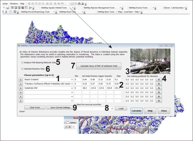 Figure 1. NetMap’s Channel Disturbance Potential tool classifies the channel network in terms of its inherent potential to experience channel changes due to storms, fires, floods, erosion, and sediment and wood transport. The model has the same structure as the ‘Habitat Creator Tool-IP’ located in NetMap’s ‘Aquatic Habitat Module’. (1) A user selects from a drop down list of parameters (gradient, width, confluences, substrate etc.). (2) Equal data divisions appropriate for individual watershed data sets are displayed and users can adjust the values (the x axis in a preference curve). (3) Weighting values (0-1) are applied to create the preference curve that can be viewed (4). The disturbance index can be created for only the defined fish bearing network (5) or only on selected reaches (6). (7) The skew of the distribution of sediment yield (in index of the punctuated supply of sediment) can be estimated and included in the channel disturbance model. Default (published) models for steelhead, coho and Chinook at be loaded (8) or a user’s individual model can be saved (9) for later retrieval (8).
The contents of 4.7 Channel Disturbance Index |