| < Previous page | Next page > |
3.11 Flash Flood IndexFlash Flood Potential Index (FFPI), A NetMap tool available in the fall of 2015
Parameter Description: The potential for flash floods in tributary basins based on four landscape attributes: (1) topography - hillslope gradient, (2) soils, (3) vegetation density and (4) wildfire impacts on soils and vegetation. The flash flood potential index (FFPI) is based on a U.S. National Weather Service Model (Smith 2003, 2010).
Smith, Greg, (2003): Flash Flood Potential: Determining the Hydrologic Response of FFMP Basins to Heavy Rain by Analyzing Their Physiographic Characteristics. A white paper available from the NWS Colorado Basin River Forecast Center web site at http://www.cbrfc. noaa.gov/papers/ffp_wpap.pdf, 11 pp.
Smith, Greg. E. (2010). Development of a flash flood potential index using physiographic data sets within a geographic information system. MS thesis, University of Utah.
Data Type: reach segment
Field Name: FFPI_datasetname; Common name: Flash Flood Potential Index-Post Fire
Field Name: FFPI_Av_; Common name: Flash Flood Potential Index, Upstream Average (e.g., summarized downstream)
Field Name: avgFF; Common name: HUC 6th field averaged FFPI, segment scale
Field Name: FFPI_pre; Common name: Flash Flood Potential Index-Pre Fire
Field Name: FFPI_preAv; Common name: Flash Flood Potential Index Pre Fire, Upstream Average(e.g., summarized downstream)
Field Name: avgFFpre; Common name: HUC 6th field average FFPI-Pre Fire
Field Name: FFPI_dif; Common name: Flash Flood Potential Index - post fire difference (e.g., difference between pre and post fire)
Field Name: FFPI_difAv; Common name: Flash Flood Potential Index-Post Fire Difference, Upstream Average (e.g., summarized downstream)
Field Name: avgFFdif; Common name: HUC 6th field average FFPI-Post Fire
Units: dimensionless, values from 1-10
NetMap Module/Tool: Fluvial Processes/Flash Flood Potential Index
 Model Description:
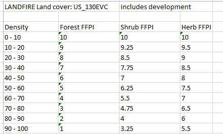
The Flash Flood Potential Index (FFPI) takes into consideration the potential for flash floods to develop, given sufficiently intense rainfall (could be combined with snowmelt), based on hillslope gradient (effects of overland flow velocity and hence time of conentration), soils (the proportion of silt and clay that contributes to surface runoff potential) and vegetation density (forest, shrub and herb), with lower vegetation densities promoting higher flash flood potential (note that the LandFire data used for vegetation densities also includes development, a proxy for impervious area). Wildfire severity can impact soils and vegetation density in the FFPI model. The FFPI model provide a dimensionless index from 1 to 10 (1 = lowest potential and 10 = highest potential).
FFPI = [M (WM) + S (WS) + V (WV)] / N, where
M = hillslope gradient (L/L), S = soil, percent sand (inversley proportional to percent silt and clay), V = vegetation (forest, shrub and herb) density ranging from 0 to 100% (and can include developed areas); MM, WS and VV are weighting factors that can be optionally applied; N is the sum of M (WM) + S (WS) + V (WV) where M, V and S are each equal to one. Thus, N = 3 if there are no weigting factors.
A FFPI score from 1 to 10 need to be assigned to classes of slope, soils and vegetation density.
 Wildfire modification to soil and vegetation FFPI scores
 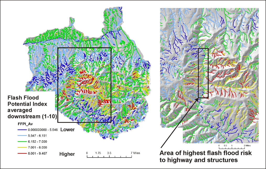 Figures 1 and 2. An example of a predicted flash flood index in the Malheur National Forest within a burned area (2015-Canyon Creek complex fire near John Day).
 Figure 3. Predicted flash flood index overlaid onto Google Earth showing areas of potential concern (impacts to highway and residences).
|