| < Previous page | Next page > |
Selection GroupingSelection Grouping (Channel Classification)
Parameter Description: The Selection Grouping classification tool provides additional functionality. Users select any parameter and define selection criteria (e.g., range or minimum or maximum) A classification builder is
used via NetMap’s interface and analysts create custom names for their classes, but limited to eight characters each. Although classification systems built using Selection Grouping can extend to the limits of the river network (e.g., no gaps in the classification), systems can be built that cover only a subset of channel segments. NetMap’s CDF tool can be used to help determine appropriate parameter thresholds, similar to the Parameter Nesting tool. In addition, classifications can be limited to and customized for specific watersheds. Selection grouping classification creates unique, non-overlapping channel classes.
Data Type: Line (stream layer)
Arc Field Name: SelClass; Common name: Parameter Nesting Channel Classification
Units: Categories
NetMap Module/Tool: Fluvial Processes/Channel Classification/Selection Grouping
Model Description:
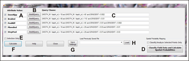 Figure 1. (A) Names are assigned to different channel classes (8 character limit). (B) The selection is conducted using a query builder that produces the ranges of attributes to classify (C). (D) This is a custom tool component that requires field data pre-processing by TerrainWorks, contact us; to see how it was used in channel and biotic classification for the US Fish and Wildlife Service in Kansas, see here. (E) Classification can occur on only a subset of channel reaches. (F) To conduct the classification. (G) Settings can be saved and reloaded (H).
An example of using the Selection Grouping tool in applying Buffington and Montgomery (2013) Classification System.
The Buffington and Montgomery (2013) classification domains of braided, dune-ripple, pool and riffle, plane bed and step pool have somewhat overlapping gradient and width to depth boundaries (Figure 2). These parameters are available from NetMap’s synthetic stream layer, although here we only consider channel slope and width to depth ratio (Table 1). The partial classification using this tool is shown in Figure 3.
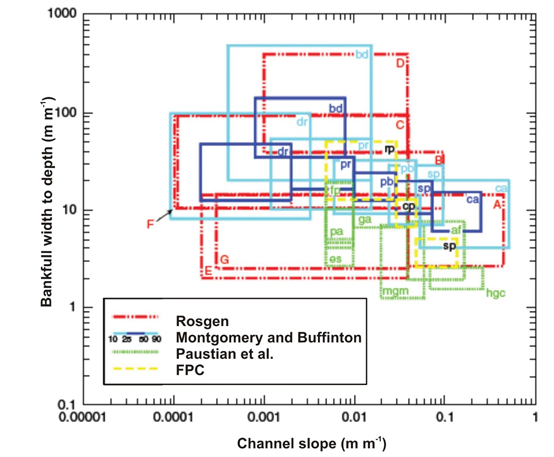 Figure 2. Montgomery and Buffington Classification parameters.
 Table 1. Buffington and Montgomery (2013) channel types defined by channel slope and width to depth ratios.
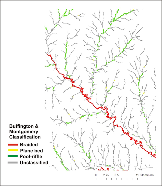 Figure 3. Partial Buffington and Montgomery classification using the Selection Grouping tool.
|