| < Previous page | Next page > |
Field LinkFIELD LINK
NetMap Module/Tool: Analysis Tools/Query Database
Model Description:
The tool, used in the office or in the field, allows users to quickly display numerous predicted attributes for any selected stream reach. A comparison can be made between predicted and field measured attributes. NetMap’s attributes can be updated in individual reaches or globally using regression correction equations, developed by the user.
Use:
The ‘Field Link tool’ is designed to facilitate the field use of the Digital Hydroscape and tool kit and to encourage field validation (and calibration) of predicted watershed parameters. Located under ‘Basic Tools’, opening the Field Link tool reveals the displayed channel network as a set of stream segments (approximate scale 20 – 200 m) showing their stream identification # and flow directions, and a tool for selecting a stream reach (Figure 1). Using the pointer, select any reach and click “OK”. A window will appear that contains many of the channel terrain attributes for the selected reach. The window will contain the IDs for the watershed, HUC, and channel segment, as well as the segment length, drainage area, and elevation (Figure 1). A separate user ID can be added. The user simply inputs field measurements into the space next to the predicted terrain value, such as channel gradient (Figure 1). There are also areas to input comments and photo ID numbers.
The field data along with the terrain predictions are saved and exported to a file in
[NetMap_FilePath]\export\field_[ID].dbf. Opening this file in a spreadsheet like Excel allows rapid comparison between predicted and field measured terrain attributes. It can also facilitate building calibration models between predicted and field values. Calibration functions can then be used to correct the predicted values of terrain parameters in the attribute table in ArcGIS. The user can also manually change the values in the attribute table (manual override all or some of the terrain predictions). In such an iterative process, many of the terrain predictions can become more accurate over time.
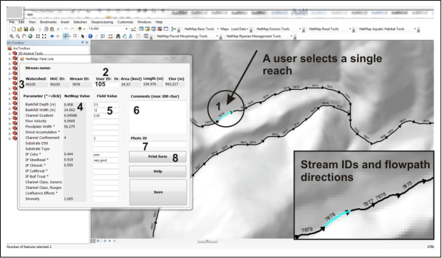 Figure 1. NetMap’s Field Link tool is designed to facilitate the collection of field data and its comparison to predicted terrain parameters. It is recommended to zoom in on the area of interest, because invoking the field link tool alters the channel network into flow paths and stream ID’s. Collection of field data and its comparison to NetMap’s values can support the creation of calibration functions to improve the accuracy of parameters. Or, field data can be directly inserted into the attribute table, thereby allowing a manual override of NetMap modeled parameters. In either case, NetMap’s terrain parameters can be made to be more accurate over time. (1) Once a channel segment is selected in NetMap’s Field Link tool, the information dialogue box opens showing relevant reach parameters (3), such as stream ID, drainage area, length etc., as well other attributes such as gradient, width etc. (4). A user can add a unique identifier (2). The user supplies field data (5), along with optional details about the site (6) and photographs (7). The field link tool is particularly useful with field computers.
|