| < Previous page | Next page > |
Drainage DensityDrainage Density
Parameter Description: Drainage density, defined as channel length per unit watershed area (km km-2), reveals the amount (or density) of channels in a watershed.
Data Type: Polygon
Field Name: DrainDens; Common Name: Drainage Density
Units: km/km2
NetMap Tool: Fluvial Processes/Drainage and Junction Density
Model Description:
Drainage density in NetMap is calculated at the scale of subbasin polygons (Figure 1). NetMap generally comes bundled with HUC 6th subbasins (polygons), but a user can import their own (custom) subbasin polygons (refer to the “import data” tool in NetMap’s Basic Tool Module).
Drainage density is generally calculated for all channels, with values in the range of two to five km km-2. In NetMap’s density tool, a user first defines whether the analysis will occur on the total network or only on a subset of the network, defined by a previous attribute query (1, Figure 2). Next, the drainage density (or of any selected attribute) can occur over the entire network or only the defined fish-bearing portion of the network (2, Figure 2). Drainage density option is selected (3, Figure 2). If the density calculation is applied only to “selected” channels, then the “drainage” density applies to channel segment-based attributes, such as channel gradient and valley widths, etc. In contrast, the density calculation can be applied only to confluence-based attributes (i.e., confluence probabilities or debris flow susceptibilities-junctions).
Technical Background:
Drainage density, defined as channel length per unit watershed area (km km-2), reveals the amount of channels in a watershed. Drainage densities in semi-arid to humid landscapes range from 2 to 12 km km-2, primarily reflecting variations in precipitation (Abrahams 1972) and lithology (Grant 1997) and see Eccker 1984 and Bloomfield et al. 2011. A large range in drainage density should also translate to a corresponding large range in the density of channel junctions with implications for the degree of channel heterogeneity found in different landscapes (see Confluence parameters in Technical Help).
In natural resource management, the parameter of drainage density is rarely used, since it has more to do with theoretical considerations of drainage evolution over long time periods than with land use. However, if the drainage density calculation is limited to the fish-bearing portion of the network, it may be relevant to issues pertaining to fish and forest management. For example, in the example shown in Figure 1, the density of the anadromous fish-bearing portion of the network (fish bearing defined as channels < 10%) ranges between less than 0.3 to approximately 2.5. This information could prove useful since it identifies which subbasins (within a large watershed) have the highest potential for habitat and perhaps the highest fish production.
.
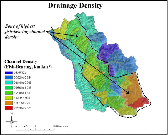 Figure 1. NetMap contains a tool for calculating the density of channels (all or only designated fish bearing) at the scale of subbasins. In the example above, the zone of highest fish-bearing density is located away from the Pacific coast in California and along the upper Eel watershed (fish bearing is defined as a gradient threshold [for salmonids] of less than 10%). Coastal areas have some of the lowest fish bearing densities because of the relatively short and steep nature of those tributaries to the Pacific Ocean.
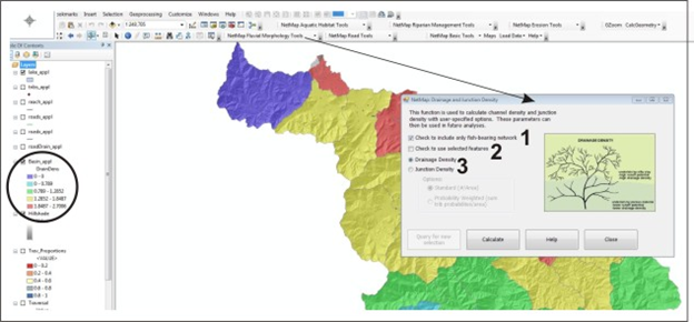 Figure 2. NetMap’s drainage density tool is used to calculate the density of tributary junctions. The calculation is applied to the entire network or only to the fish bearing portion (1). The density tool is applied to currently selected objects or to other objects (2). Drainage density is selected (3). In the example shown, the density of fish-bearing streams (channels less than 12%) is shown for the Wilson basin (located in coastal Oregon). The same tool is used to calculate “junction density” (refer to the ‘Tributary Confluence Density’ tool).
|