| < Previous page | Next page > |
8.2 Delineate Riparian ZonesTool Description: NetMap's riparian zone delineation tool is designed to delineate riparian zones based on site specific conditions related to (1) wet areas (e.g., depth to water or wetlands), (2) floodplain extent, (3) in-stream wood recruitment and (4) thermal energy to streams. The tool examines these factors (using other NetMap Riparian Tools) on a stream reach by stream reach (approximately 100 m length scale) with right channel - left channel distinction. See NetMap's floodplain, in-stream wood recruitment and shade/thermal energy tools.
An analyst selects which ones of the four riparian processes to consider (any number between one and four processes). NetMap's riparian delineation tool allows analysts to make adjustments to each of the riparian processes considered. For example, thresholds to wet areas (depth to water) can be applied (for example, < 15 cm) and or a maximum lateral extent can be selected (say 30 m). Next, the floodplain (height above channel) is selected, such as two multiples of bank full width, three multiples etc. (often two multiples of bankfull depth) and a maximum lateral extent can be applied if desired. Next, for in-stream wood recruitment, a user can select what percentage of the instream wood volume to include in the riparian zone (0 to 100%). Finally, an analyst can determine whether the resultant riparian zone (created by the riparian processes selected) will also meet some type of thermal loading threshold (e.g., how much thermal energy is shaded compared to fully vegetated conditions).
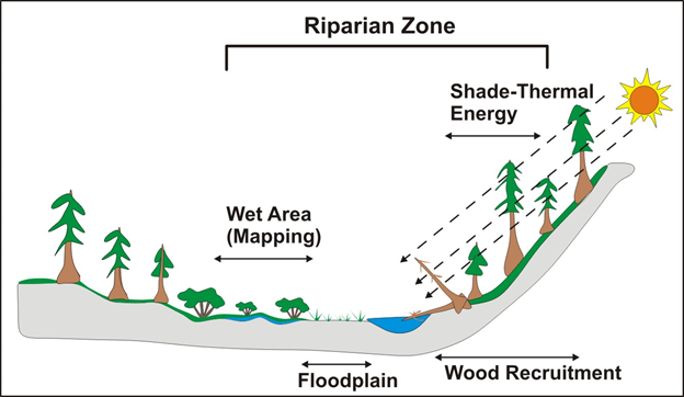 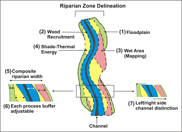 Figures 1 (left) shows the four riparian processes that can be included in NetMap's riparian zone delineation tool (any combination of the four can be used, including only one). Figure 2 (right) illustrates how the riparian zone delineation tool works. Based on variable site to site channel-riparian environments and the contraints imposed by analysts (number of riparian processes selected and on the lateral limitations imposed, e.g., #1 - #6), the mapped riparian zone, by process, will vary along the channel and across a watershed, with left channel - right channel distinction (#7). Then for each reach in NetMap's synthetic stream layer, a single maximum of riparian zone extent is created (#5).
NOTE, prior to running this tool, you will need to access and process Vegetation Data, such as LEMMA (see Tool) or other vegetation data - the latter option may require some data pre-processing by TerrainWorks. If using vegetation data other than LEMMA, contact TerrainWorks.
Data Types: The riparian delineation tool produces up to four polygon shapefiles, one each for wet areas, floodplains and in-stream wood recruitment (with left channel - right channel distinction). Another data type includes three attribute in the reach shapefile, left and right channel side riparian zone widths and total width.
Polygons
Field Name: wet_areas_basinID; Common Name: Wet areas riparian polygon
Field Name: FP_Riparian_basinID; Common Name: Floodplain riparian polygon
Field Name: TreeHtBuffer_basinID; Common Name: In-stream wood recruitment polygon
Field Name: Rip_Extent_basinID; Common Name: Predicted riparian zone extent, with left channel - right channel distinction
Reach attributes (in reach shape file)
Field Name: RipWid_r; Common Name: The width (m) of the predicted riparian zone of the right side of the channel (looking downstream).
Field Name: RipWid_l; Common Name: The width (m) of the predicted riparian zone of the left side of the channel (looking downstream).
Field Name: RipWid_avg; Common Name: The average width (m) of the predicted riparian zone.
Field Name: RipExtent; Common Name: The total width (m) of the predicted riparian zone (left channel and right channel riparian zones combined).
Field Name: RipFP_l; Common Name: The riparian floodplain width (m), left channel side.
Field Name: RipFP_r; Common Name: The riparian floodplain width (m), right channel side.
Field Name: WAM_l; Common Name: The riparian wet areas width (m), left channel side.
Field Name: WAM_r; Common Name: The riparian floodplain width (m), right channel side.
Field Name: LWD_width_r; Common Name: The riparian floodplain width (m), right channel side.
Field Name: LWD_width_l; Common Name: The riparian floodplain width, left channel side.
Field Name: ThrmRip; Common Name: Solar radiation with the delineated riparian buffer.
Field Name: ThrmRipMax; Common Name: Solar radiation with maximum vegetation width (reference)
Field Name: ThrmDif; Common Name: Solar radiation difference between delineated riparian zone width and reference.
Field Name: ThrmBuf; Common Name: Additional buffer width for thermal protection, given the selected thermal loading threshold.
Units: meters, watt-hours/m2
NetMap Module/Tool: Riparian - Riparian Zone Delineation
Model Description: Follow the steps below.
STEP 1. Wet Areas
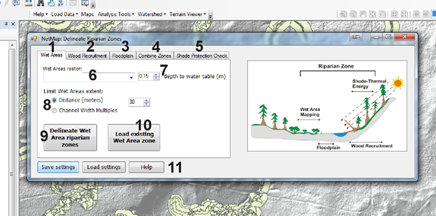 Figure 3. Open the Riparian Zone delineation tool interface. There are five components and five tabs (1 - 5). The first one shown in this figure (1) addresses "wet areas", in this example defined as distance between ground surface and ground water table. (6) A wet area data file (raster shapefile) is selected. (7) A threshold for depth to water is defined, such as < 0.15 m. (8) The delineated wet areas can be limited in lateral extent. (9) The wet areas that are to be included in the riparian zone are delineated. If the analysis has already occurred, a user can simply load the polygon shapefile showning this zone (10). The tool contains a few save and load data settings (11).
Figure 4. A schematic of NetMap's riparian zone delineation tool. Up to four riparian processes can be selected for inclusion into the riparian zone mapping (1 - 4). They are combined to create a composite riparian zone delineation (5). Each of the riparian processes can be limited in lateral extent. The delineated riparian zone has right side channel and left side channel distinction (7).
STEP 2. In-stream Wood Recruitment
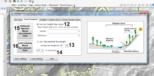 Figure 5. Step 2 in delineating riparian zones involves in-stream wood recruitment. (12) A user can select a raster of tree heights, and separate rasters for conifer and deciduous can be selected if available; if both are selected, then the maximum tree height is used. If no tree height rasters are availble or if they contain data that represents altered forest conditions (e.g., lack of trees, shorter trees due to fire or timber harvest), then a user can apply a "site potential" tree height everywhere along the streams. (14) The proportion of tree volume recruited to the stream (0 - 100%) can be selected (14); this feature will be activated by summer 2015. (15) The riparian zone predicted by in-stream tree recruitment is calculated. If the tool has already been run, a user can simply load the riparian instream wood recruitment zone, with left channel - right channel distinction (16).
STEP 3. Floodplains
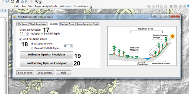 Figure 6. A floodplain type is selected, defined by the number of bankfull depths above the channel that was used in NetMap's floodplain mapping tool (17). (18) The lateral extent of the floodplain can be limited; e.g., in low gradient and wide valley floors, active floodplains can extend for kilometers. (19) The floodplain component of the riparian zone is delineated. If the tool has previously been run, a user may simply load the floodplain - riparian zone, with left channel - right channel distinction (20).
STEP 4. Combining Zones
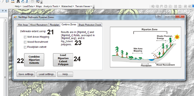 Figure 7. This tab allows a user to combine the delineated riparian zones for wet areas, in-stream wood recruitment and floodplains. (21) A user can select one, two or all three riparian zone process to combine. (22) When combining the zones, the maximum extent of the three is used to delineate the single, riparian zone lateral extent, at the scale of individual channel reaches (of approximately 100 m length scale) with left channel - right channel distinction. The output data layer names are shown on the interface (23). If the tool had already been run, a user simply loads the polygon (24). Although the polygon encompasses the channel, the reach attributes include riparian zone left side channel, riparian zone right side channel, the average riparian zone width and the total riparian zone width.
STEP 5. Running a Thermal Energy Check
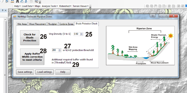 Figure 8. An option in NetMap's riparian zone delineation tool is to check on whether the delineated riparian zone provides the required thermal protection. In this calculation, the width of the delineated riparian zone (with channel right side and channel left side distinction) is used, along with a selected vegetation density (25), to estimate the thermal energy reaching the channel compared to a streamside vegetation with a large width component (1000 m). Users provide a thermal difference threshold value (27) in terms of watt-hours per square meter; this component of the tool employs NetMap's Thermal Energy Sensitivity tool. (26) A user performs the check for shade protection and any reaches that do not meet the threshold difference (e.g., less than 200 watt-hours/m2 using the example in the interface) are identified. A user can then apply the tool (28) to calculate what additional width of the delineated riparian zone will meet the threshold difference in (27).
Examples follow.
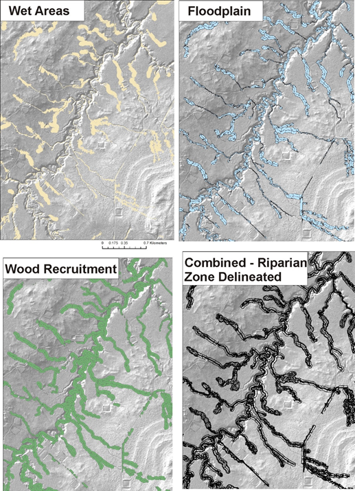 Figure 9. Each riparian zone process is delineated (polygons), as shown above, and then combined (lower right panel). The lateral extent of each process can be adjusted by the analyst including setting thresholds for wet areas (depth to water, in this example less than 15 cm and maximum lateral extent of 30 m), floodplains (mapped at an elevation equivalent to two multiples of bank full depth and a maximum lateral extent of 30 m), and in-stream wood recruitment (100% wood recruitment included, but can be adjusted to be less than 100%).
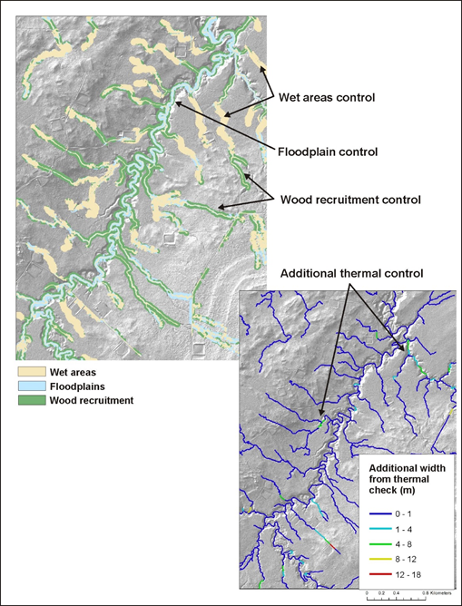 Figure 10. In a spatially variable riparian zone, wet areas control it in some areas, floodplain in other areas, and in-stream wood recruitment in yet other areas.
Thermal in-stream sensitivity can also be a factor in a subset of channel reaches.
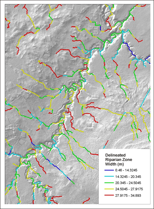 Figure 11. The width of delineated riparian zones varies from less than 14 m to 35 m, depending on the spatial variability in riparian processes, including wet areas, floodplains, wood recruitment and thermal loading.
|