| < Previous page | Next page > |
Bull Trout (Empirical)77
Fish Habitat Model: Bull trout
Parameter Description: The bull trout model calculates the reach-scale probability of bull trout presence using an empirical model (Rich et al., 2003).
Data Type: Line (stream layer)
Field Name: PBullTR; Common Name: Bull Trout
Units: Probability
NetMap Module/Tool: Aquatic Habitats/Bull Trout Habitat
Model Description: The NetMap empirical bull trout model is taken from a modeling study which was completed using data from 112 1st – 4th order streams in the Upper Bitterroot River, Montana (Rich et al., 2003). No sampling occurred: 1) where the stream gradient was greater than 20%; 2) above barriers > 2 m such as falls; 3) where stream width was greater than 7 m due to problems with sampling logistics; 4) where contributing area > 130 km2; 5) at elevations lower than 1340 m or higher than 1945; or 6) at channel gradients higher than 15.6% (Rich et al., 2003). Presence/absence of bull trout was measured using electro-fishing and all sampling was completed within a five-year time period. Predictor variables of from local habitat, watersheds scale characteristics, and biotic factors were tested during model development to generate the final model to address the diversity of habitat needs and size. The model calculates the probability of bull trout presence using a logistic regression with parameters: wetted stream width, reach gradient, large woody debris (LWD), basin area, average channel slope, elevation, main stem abundance of bull trout, and the presence or absence of brook trout (Equation 1,2):
The Bull trout model is implemented in the NetMap Habitat Add In, under Aquatic habitat models\Empirical\Bull Trout (Figure 1). Users are required to select a shapefile of reaches that is already within the FieldMap Table of Contents and has reaches selected. The reach shapefile will need to have attributes for reach gradient (m/m), basin area (km2), downstream elevation (m), and channel gradient (m/m). Channel gradient is the average gradient that is measured from the mouth to the reach with the highest elevation (see help for node-based streams). Four threshold values are provided for largest contributing area, lower limit, steepest gradient, and widest channel limits for habitat and these defaults are obtained from the limits to measured values in Rich et al. (2003). Users can extrapolate beyond these values at their own risk. Optional fields include those for large woody debris (LWD; number of pieces per 100 m reach that are > 3 m long and > 10 cm in diameter), main stem abundance of bull trout (0 = no bull trout, 1 = < 5 fish/100 m reach, and 3 = > 5 fish/100 m reach), and the presence/absence (=1/0) of brook trout. Where fields cannot be provided, the user must select a constant state from the drop down box. In addition users must provide a field for either bankfull width or wetted width (m). Bankfull width will be converted to wetted width using the equation provided, which was calculated from data provided by the Kalispel Tribe Initiative (Equation 3) or users can provide their own intercept and coefficient for a linear regression based on their own data.
Results of the bull trout calculation are stored in the reach attribute “PBullTR” and this will be mapped automatically when calculations are complete. Results will be overwritten by future bull trout model runs unless these values are saved to a new user-defined field.
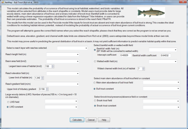 Figure 1. Interface for the Bull trout model in NetMap
Technical Background: Several contributing factors have led to the decline of bull trout populations in streams of the US Pacific North West where bull trout are listed as threatened (USFWS, 1998). Non-native fish, such as brook trout, compete with bull trout for food and other resources (Rieman and McIntyre, 1993). Increases in road densities and the presence of barriers, which reduce effective network size, can isolate populations and create unsustainably small populations (Dunham and Rieman, 1999). In addition anthropogenic habitat degradation and fishing exploitation have led to declines in bull trout populations.
We ran the bull trout model for two main scenarios varying (1) LWD and (2) channel width and gradient. Within each scenario, we varied the presence of brook trout and the main stem abundance of bull trout. All other variables were held constant at the median values given in Rich et al. (2003): basin area (11.7 km2), elevation (1725 m), and network slope (5.6 %). For the LWD run, width and gradient were held at 3.1 m and 5.6 % respectively. For the width and gradient run LWD was held at 15 pieces / 100 m.
The bull trout model response to varying LWD, main stem abundance of bull trout, and the presence of brook trout as shown in Figure 2; at 60 pieces of wood, all values for bull trout occurrence will be greater than 0.99. Plots of varied channel width and gradient indicate increasing probabilities of bull trout occurrence with increasing width and decreasing gradient (Figure 3). The lowest probabilities of bull trout occurrences ensue when brook trout are present and there are no main stem bull trout. Conversely, highest occurrences of bull trout ensue when there are no brook trout and main stem bull trout populations are greater than five per 100 m of stream. The plots indicate model applicability which should be limited to reaches within the range of sizes and gradients that were sampled by Rich et al. (2003). Streams were sampled up to 6.8 m wide, 15.6 % channel gradient, and 129.7 km2 basin area (Rich et al., 2003).
If the bull trout model results will be used in the Piscicide model (in Aquatic Habitat Module), the model should be run as an intrinsic potential model instead of a probability of occurrence model. Two adjustments are made to the inputs: (1) the main stem abundance of bull trout should be selected to be strong and (2) brook trout should be selected to be absent. By removing the biotic factors that can be altered, the physical determinants of habitat remain to calculate the intrinsic potential of bull trout habitat.
 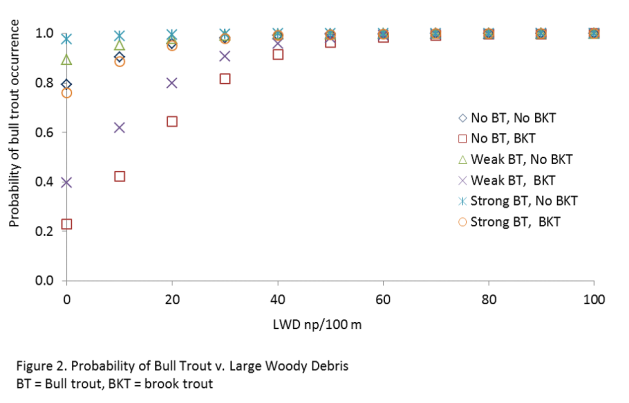 Figure 3. Probability of bull trout occurrence varying channel width, gradient, presence of brook trout and the main stem abundance of bull trout.
|