| < Previous page | Next page > |
3.7 Landslide-Channel InteractionsLandslide-Channel Interactions
Parameter Description: Landslide deposits, containing boulders, mixed grain sediment, and logs, can have significant impacts on channel and valley morphology. In NetMap, categories of landslide-channel interactions (following the deposition of a landslide or debris flow into a channel), including categories of 1) colluvial deposit, channel-valley burial, 2) morphologically significant, 3) dilution – scouring debris floods, and 4) hyper dilution. Predictions are based on an empirical model using data from the Pacific Northwest portion of the United States and Canada. See also NetMap's Erosion Tools that include predictions for 1) shallow failures, 2) debris flows and 3) deep-seated landslides/earthflows.
Data Type: Line (stream layer)
Field Name: SP_CLASS; Common Name: Mass Wasting – Channel Interactions
Units: na, classes
NetMap Module/Tool: Fluvial Processes/Landslide-Channel Interactions
Model Description:
Landslides and debris flows deposits have a range of morphological consequences in streams and rivers. NetMap’s tool is used to classify different morphological effects in stream channels focusing on debris flows that deposit at headwater-mainstem tributary confluences. Classification covers four types based on regional data in the Pacific Northwest: 1) channel-valley burial with colluvium, 2) morphologically significant in-stream deposits, 3) dilution and scouring debris floods, and 4) hyper dilution (Figure 1). The model is based on the relationship between debris flows with volumes of between approximately 1000 and 5000 m3 (typical volumes of debris flows in first- and second-order channels) and channel gradient and flow in third through fifth-order channels (where debris flows deposit), i.e., stream power (e.g., channel gradient multiplied by drainage area).
NetMap’s classification tool allows users to specify the stream power associated with any of the four classification types (Figure 2). In the absence of site-specific data, it is recommended to use the default values. The model is designed to reflect likely effects of debris flows having typical volumes of between 1000 and 5000 m3 and apply mainly to deposits less than 5 years old (the limit of the data used in Figure 1). Although the tool is meant primarily to address debris flow deposits, it may also be used classify landslide deposit effects, as long as the volume range and material composition is similar (e.g., boulders, mixed grain sediment, logs and whole trees). The tool creates a network wide classification of likely debris flow (or landslide) channel interactions (Figure 2).
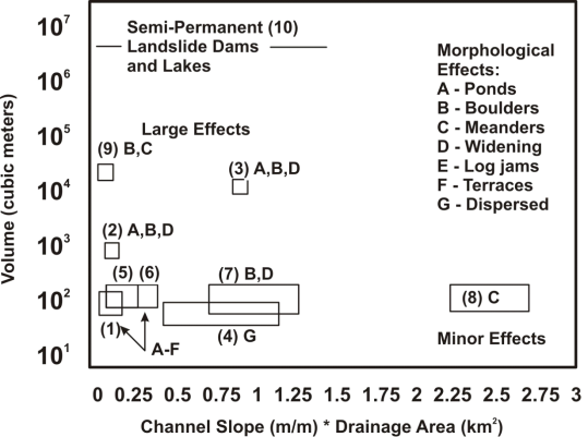 Figure 1(A). Effects of debris flows on morphology of larger streams vary based on volume of debris and stream power of receiving channel. Data include Olympic Mountains of western Washington #1-4 (Benda et al. 2003), central Oregon Coast Range (#5, Benda 1990; Everest and Meehan, 1981), Queen Charlotte Islands, British Columbia (# 6, Hogan et al., 1998), Oregon Cascades (#7 and #8, Grant and Swanson, 1995), Suislaw River, Oregon (#9), and #10 (Costa and Schuster, 1988).
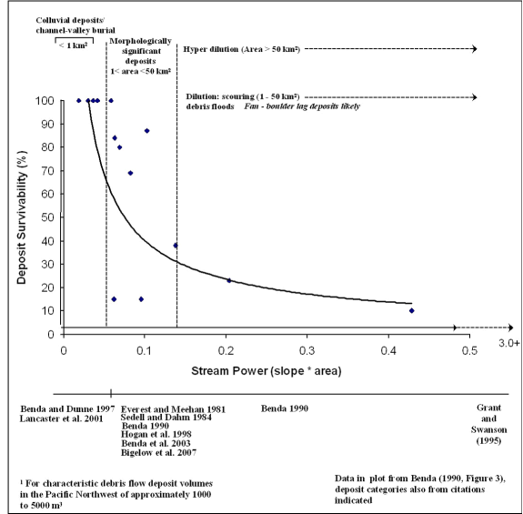 Figure 1(B). NetMap’s ‘Landslide-Channel Interaction’ tool uses empirical data to create four domains of channel influence: 1) colluvial deposits that bury channels and valleys (in basins less than 1 km2), 2) deposits that are morphologically significant and create boulder deposits, log jams, and sediment deposits, 3) dilution, little onsite effect but scouring debris floods downstream are likely (particularly in the presence of logs), and 4) hyper dilution, little morphological effects onsite or downstream. Such patterns may also apply to landslides of similar volumes and composition. Adapted from Benda et al. (2003) and Miller and Burnett (2007).
Technical Background:
In certain landscapes, low-order channels prone to debris flows comprise up to 80% of a channel network, and hence network topology can influence the spatial diversity of channel and valley morphologies (Benda et al. 2004). In depositional areas, debris flows construct levees (Canon and Bonny 1902); build fans at tributary junctions (Dietrich and Dunne 1978); create boulder deposits along fan margins (Benda 1990; Wohl and Pearthree 1991); form ponds at fan constrictions (Everest and Meehan 1981); create wide valley floors (Grant and Swanson 1995); force channel meanders (Benda 1990); and spates of debris flows can lead to widespread channel aggradation and formation of terraces (Wohl and Pearthee 1991; Robert and Church 1986; Miller and Benda 2000). In addition, debris flows can incorporate logs and whole trees that have accumulated in low-order channels over decades to centuries and they deposit them on fans, valley floors, and in channels at low-order confluences (Swanson and Lienkaemper 1978; Hogan et al. 1998; May 1998).
Classification of debris flow effects in streams can be used in a variety of ways. For instance, one could evaluate whether debris flows will have morphologically destructive or constructive effects. Negative effects of debris flows may include immediate burial of existing habitat and direct mortality of aquatic biota; increased fine sediment in gravels onsite and downstream that suffocates fish eggs in gravel (Everest et al. 1987; Scrivener and Brownlee 1989); increased bedload transport and lateral channel movement due to heightened sediment supply that scours fish eggs; and loss of pools that reduces rearing habitat (Frissel and Nawa, 1992; Hogan et al. 1998). Such effects may be associated with any of the deposit types, but in particular “dilution-scouring debris floods” may be particularly damaging, while “hyper dilution” may have no long-term in-stream morphological consequences. In addition, “morphologically significant” may be interpreted as being destructive to aquatic habitats, but it may also be viewed as contributing to habitat formation over time.
For example, debris flows are a “disturbance” when viewed by ecologists (Swanson et al. 1988) and the pivotal role of certain types of disturbances in maintaining productivity and diversity in aquatic ecosystems is gaining increasing recognition (Resh et al. 1988, Reeves et al. 1995). Beneficial effects of debris flows on aquatic systems include formation of ponds that become occupied by fish and beaver (Everest and Meehan 1981); release of nutrients due to buried organics in anaerobic environments (Sedell and Dahm 1984); deposition of woody debris that creates sediment wedges and forms pools (Hogan et al. 1998); deposition of boulders that trap sediments and create complex habitats (Reeves et al. 1995); formation of wider valley floors that contain larger floodplains (Grant and Swanson 1995); and increased biological productivity (Roghair et al. 2002). Spates of debris flows may also contribute to watershed-scale habitat diversity, including in riparian forests (Nierenberg and Hibbs 2000; Nakamura and Swanson 2002).
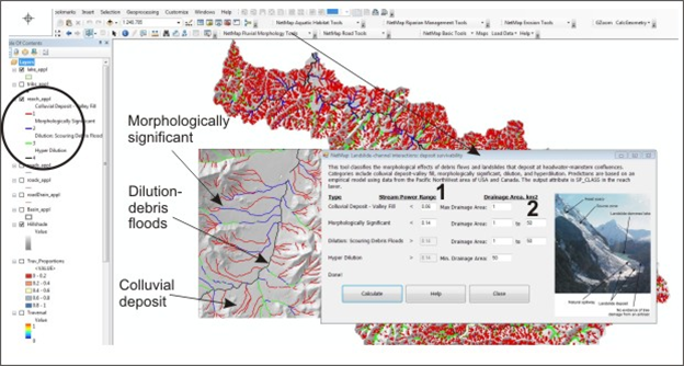 Figure 2. NetMap’s Landslide-Channel Interaction tool creates a four-field classification system based on stream power (1) and drainage area thresholds (2); e.g., see Figure 1. Default stream power values are based on regional data and on a typical (regional) debris flow volume of several thousand cubic meters. The classification systems should also work for non-channelized landslides of similar volumes and composition. The user can adjust stream power values (2) if watershed-specific data are available.
|