| < Previous page | Next page > |
DeliverySediment Delivery by Landsliding and Debris Flows
Wood Recruitment by Debris Flow
Model Description: An important characteristic of watersheds is the connectivity of hillslopes to stream channels. Here, connectivity is considered from the perspective of sediment and organic material delivery via mass wasting processes, specifically landslides and debris flows. The parameter can be interpreted in several different ways: 1) a general assessment of the intrinsic connectivity of hillslopes to channels, via mass wasting, 2) the delivery potential of sediment from mass wasting to fish bearing streams, and 3) an index of wood recruitment by debris flows (source areas and runout paths).
The "Delivery" tool allows an analyst to adjust the channel gradient threshold from which to calculate the likelihood of sediment and wood delivery by shallow landslides and debris flows. The tool is used to adjust the delivery parameters of: 1) Generic Erosion Potential (GEP) 2) Shallow Landslide Potential, and 3) Debris Flow.
Data Type: Grids (Affects the following Grids)
Field Name: GEP_DEL_GRID; Common Name: Generic Erosion Potential-Delivered (in Generic Erosion Potential [GEP] Tool)
Field Name: LS_DEL_GRID; Common name: Landslide-delivery (in Shallow Landslide Potential Tool)
Field Name: LS_PROP_GRID; Common name: Shallow Landslide Source Proportion (in Shallow Landslide Potential Tool)
Field Name: TRAV_GRID; Common Name: Debris flow traversal (the probability of debris flows traversing channel grid cells) (in Debris Flow Tool)
Field Name: trpr_basinID; Common Name: Traversal proportion grid (in Debris Flow Tool)
Field Name: SrTc_basinID; Common Name: Source Traversal proportion grid (in Debris Flow Tool)
NetMap Module/Tool: Erosion/Delivery
NetMap Module/Tool: Riparian Management/Upslope wood source (it's effected by delivery)
Model Use:
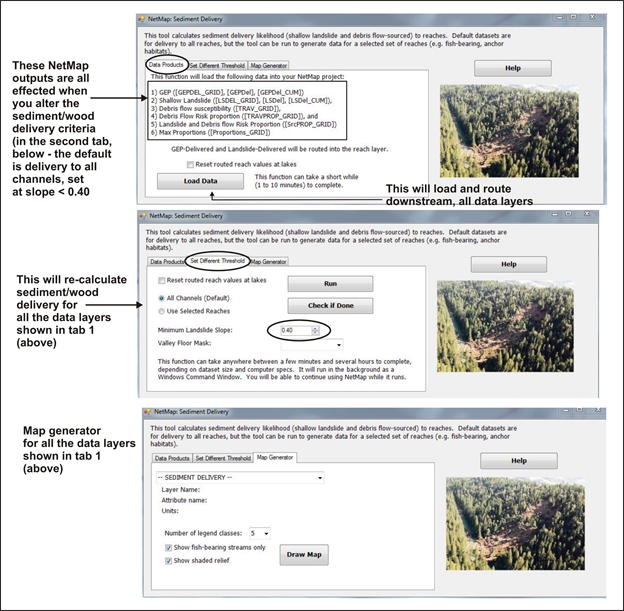 Figure 1. NetMap's "Delivery" tool predicts the delivery of sediment and wood from landslides and debris flows to stream channels. The prediction of delivery is based on defining a channel gradient thresholde (2nd tab) in the tool interface. The default threshold is 0.40 (e.g., all stream channels). However, an analyst might wish to select a channel gradient threshold of 0.10 (e.g., <= 10%) for anadromous habitat or 0.20 (e.g., <= 20%) for resident fish. One can see from Figure 2 that the number of landslide areas that would be predicted to deliver to stream channels is much greater for a threshold of <=20% compared to channels <=4%. Once an analyst has run the Delivery tool, the outputs that it affects (6 grids) are located in their respective modules (shown in tab 1 above), including Generic Erosion Potential (GEP), Shallow Landslide, and Debris Flow.
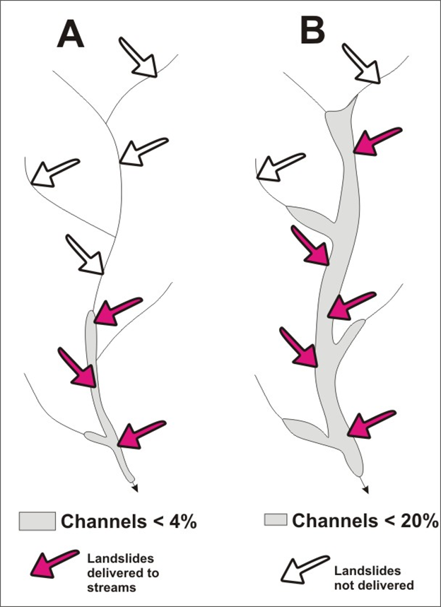 Figure 2. NetMap's Delivery tool is used to define sediment and wood delivery potential to stream channels from landslides and debris flows by selecting a channel gradient threshold (Figure 1). A gradient threshold of less than or equal to 4% means far fewer areas will be predicted to delivery to stream channels compared to a gradient threshold of less than or equal to 20%.
|