| < Previous page | Next page > |
Topographic RoughnessTopographic Roughness (Stream Adjacent)
Parameter Description: The degree of changing topographic gradient between a channel and the stream adjacent hillside. Near stream topographic roughness may have influences on channel morphology and the occurrence or absence of wide valley floors or floodplains.
Data Type: Line (stream layer)
Field Name: ; Common name:
Units: L/L
NetMap Module/Tool: (pending)
Model Description:
Local topographic controls on channel morphology are gauged using the variability in surface gradient within a specified buffer adjacent to each channel. This measure of local roughness is calculated as the root-mean-square of differences from the channel gradient:
R = SQRT(S(MAX(q-qc,0))/n)
Here qc is channel gradient, q is gradient of each pixel (taken from the raster file of slope) within a specified radius, and n is the number of pixels within the radius with slope values greater than or equal to the channel gradient. High values of channel-local roughness indicate high lateral controls on channel morphology and high potential for sediment inputs to the channel. The radius over which roughness is calculated is a specified number of channel widths, given in the River Builder’s parameters text file.
Technical Background:
Near stream topography, such as ridges and bedrock outcrops, can strongly influence local channel and valley morphology. For instance, ridges that intersect streams or bedrock outcrops that emerge close to channels can create falls and rapids, increase sediment storage, and form pools (Figure 1). Steep bedrock near streams can also lead to rockfalls and talus that impacts local channel morphology.
Local topographic controls on channel morphology in NetMap are gauged using a measure of topographic roughness or variability in surface gradient within a specified area adjacent to each channel. The measure of local roughness is calculated using the difference between hillslope and channel gradients within a specified radius from the channel; the radius over which roughness is calculated is defined in terms of channel widths. Topographic roughness for each grid cell is calculated by taking the average of the elevation differences among its neighboring cells (squared and then square rooted to create positive values, referred to as the root-mean-square) (Riley et al. 1999). Measures of topographic roughness are sensitive to the resolution of elevation data and the scale over which it is measured.
Near stream topographic roughness can indicate the occurrence of steep cliffs and thus talus (that can impinge on streams) in certain landscapes (Figure 2). High values of stream-adjacent roughness indicate the potential for lateral topographic controls on channel morphology (topographic hard points, ridges and bedrock outcrops) including increased supply of coarse sediment from rockfalls to the channel.
High near stream topographic roughness should correspond to constrained valleys and the distribution of such roughness across a watershed has implications for riverine ecology (Figure 3).
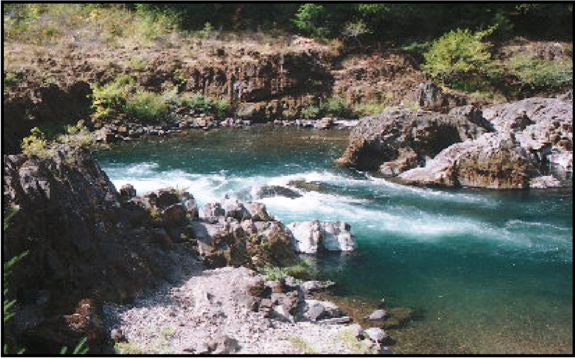 Figure 1. Some river systems have significant bedrock controls on river form as shown in the upper Umpqua River in the Oregon Cascades. Measures of stream-adjacent topographic roughness, combined with geology (rock strength), can be used predict their likely occurrence. Aerial photographs and ground surveys can also be used to register their importance for fluvial geomorphology and aquatic habitats. NetMap includes a parameter of near stream topographic roughness that provides a rough proxy for bedrock controls on river morphology.
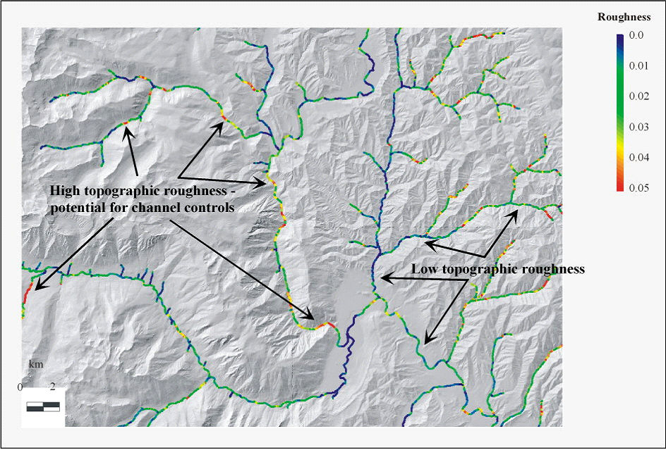 Figure 2. Stream-adjacent topographic roughness can indicate the occurrence of topographic forcing on river morphology that can include ridges, bedrock outcrops, rockfalls, and talus. Such controls can lead to certain types of river morphology. Stream-adjacent topographic roughness can vary spatially in a watershed contributing to riverine heterogeneity. River habitats associated with high topographic roughness (e.g., ridges, bedrock outcrops, and rockfalls) may be more resistant to both natural disturbance and human impacts.
 Figure 3. NetMap contains a tool for analyzing near stream topographic roughness. High roughness values may indicate where topographic controls on river morphology occur in watersheds. Such areas may also correspond to valley constrained reaches.
|