| < Previous page | Next page > |
Sub-basin OverlapOVERLAP TOOL - SUBBASINS (Risk Analysis)
NetMap Module/Tool: Analysis Tools/Risk Analysis
NetMap is used to conduct different types of risk analyses that involve identifying the spatial juxtapositions between predicted hazards (erosion, flooding potential, wildfire risk etc.) and sensitive and valuable aquatic resources. This tool works at the subbasin scale; see also the tool that works at the reach scale.
Overlap Tool
Model Description:
One component of a risk analysis, in the broadest sense, is to identify where areas of likely impacts (such as erosion, landslides, road drainage diversion, lack of in-stream wood, increased thermal loading etc.) spatially overlap with areas of sensitive resources. For example, landslide potential and fish habitat quality are not distributed uniformly across watersheds. Some areas have higher potential for failure than others. Across a stream network, some reaches or valley segments have a higher potential for quality fish habitat. One objective of a risk analysis is to determine where the highest potential for human caused disturbance (such as erosion) overlaps with the best habitats.
NetMap contains a tool to identify overlaps between predicted high risk areas and predicted areas of high quality aquatic habitat at the scale of subbasins; also see the tool that works at the scale of stream reaches. Data summarized at the subbasin scale must be available, such as road density, erosion potential, fire risk potential, and fish habitat potential etc. To develop data summaries at the subbasin scale, see NetMap’s Sort & Rank Tool. Some subbasin classifications of environmental attributes are pre loaded with the datasets.
See Figures 1 and 2. These capabilities also exist in NetMap’s Browser Tools.
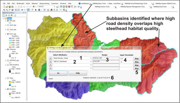 Figure 1. NetMap’s Subbasin Overlap tool utilizes a polygon subbasin shapefile. HUC 6th field subbasins are standard in Digital Hydroscape datasets but users can import other subbasin polygon layers. To summarize stream segment (line), road (line) or hillslope (grid) data at the subbasin scale, use NetMap’s Sort & Rank Tool. Once data summaries (or subbasin classifications) are available, a user selects the subbasin overlap tool from the Risk Analysis component of the Basic Tools. A user then selects the subbasin classification attribute from the drop down list (1), such as road density. Next, another subbasin data summary is selected, such as fish habitat (2). A third and fourth set of subbasins can be included. The range of the subbasin values are provided (3) and users can opt to view the associated subbasin maps (5). Thresholds are selected to define the search or overlap criteria. In the example above, subbasins that have a road density greater than 1.5 km/km2 are examined with respect to steelhead habitat quality greater than 0.8. Two subbasin overlaps were identified (outlined in light blue-green).
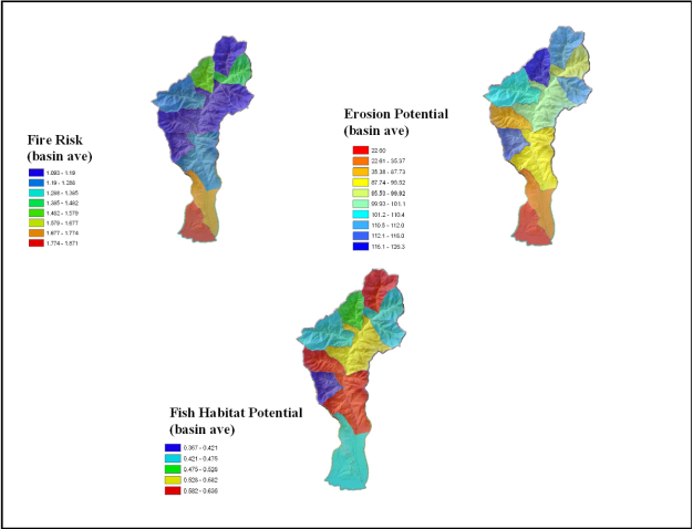 Figure 2. NetMap’s Subbasin Overlap Tool can be used to examine the spatial relationships among a series of watershed attributes. In the example above, subbasin data summaries (classified by average values, see Sort & Rank Tool) for fire risk, hillslope erosion potential and fish habitat potential indicate where potential hazards (at the subbasin scale) overlap with sensitive resources.
|