| < Previous page | Next page > |
5.4 Earthflows and Deep-Seated LandslidesEarthflows and Deep-Seated Landslides
Parameter Description: NetMap contains several tools that can be used to detect large deep-seated landslides and earthflows, particularly if they have toes that intersect the adjacent valley floors (either dormant or active). Tools include: 1) floodplain or valley width, 2) stream longitudinal profiles, 3) grid profiling (hillslope cross sectional or ridge to valley profiles), 4) Generic Erosion Potential and 5) debris flows. Detection criteria include abrupt floodplain or valley widening above the landslide with a narrowing adjacent to the toe, an abrupt increase in stream gradient near the downstream end of the landslide accompanied by an lowering of gradient upstream of the feature, a deflation in elevation across the hillside of the landslide, and a concave up profile from ridge to valley (see figures below).
Data Type: River longitudinal profiles of elevation, gradient, and floodplain/valley width. Generic Erosion Potential (GEP).
Field Name: na; Common name: na
Units: Changes in channel slope gradient
NetMap Module/Tool: See above
Model Description:
Large landslides and earthflows can have major influences on local channel and valley morphology (Figures 1 and 2). Effects can include a lowering of channel and valley gradients and a widening of floodplains and valleys (Grant and Swanson 1995). Three of NetMap's tools can be used to identify large deep-seated landslides and earthflows that impinge on valley floors including: 1) Floodplain/valley mapping, 2) River longitudinal profiles, and 3) Grid profiling.
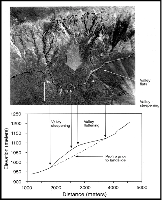 Figure 1. Large, ancient deep-seated landslides can be a source of habitat development and heterogeneity. The landslide depicted here, located in eastern Washington, has resulted in a large bulge in the longitudinal profile of the river. Upstream of the landslide low gradient valleys and channels have created floodplains and lower gradient, meandering channels. Younger deep-seated landslides can pose a threat to aquatic resources through increased erosion and turbidity. Because of the rarity of large landslide events, the majority of such features in a watershed should be old. NetMap contains several tools for identifying large deep-seated landslides and earthflows.
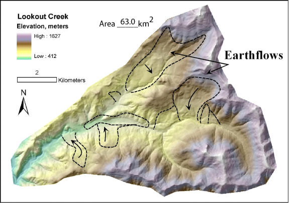 Figure 2. Large landslides and ancient earthflows are numerous in many mountain landscapes such as in certain parts of the Oregon Coast Range (Roering et al. 2005), southwest Washington (Dragovich et al. 1993) and shown here in the central Oregon Cascades (Grant and Swanson 1995). Such landslides may be important sources of riverine heterogeneity.
One method for estimating locations of deep-seated landsliding or earthflows in NetMap is based on longitudinal patterns of channel gradients and valley widths. NetMap contains a Longitudinal Profiling Tool located in Basic Tool Module. Recent or active deep-seated slides can cause certain patterns in stream longitudinal profiles. The user can visually search for anomalous patterns such as “bumps” in longitudinal profiles, associated increases and decreases in channel and valley gradients, and local valley widening (Figure 3). In addition, a channel is often forced to the opposite side of the valley at the toe of deep-seated landslides or earthflows. Associated hillslope terrain supports this interpretation, including a lobate toe, a main channel pushed across the valley floor, and an arcuate failure scarp (Figures 2 and 4). Analysis of air photos and field observations would be helpful to confirm the occurrence of a deep-seated landslide at those locations. Other examples of using NetMap's profiling tools to detect deep-seated landslides and earthflows are shown in Figures 5 through 8.
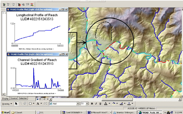 Figure 3. The longitudinal plotting tool in NetMap can be used to identify perturbations in the profiles of relief, gradient, and valley width that may be caused by large landslides and earthflows. A large landslide along the mainstem of the Mattole River is highlighted in this figure.
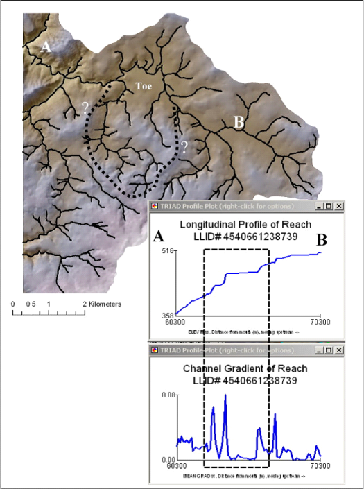 Figure 4. NetMap’s tool kit can be used to detect deep-seated landslides and earthflows by searching for variations in longitudinal profiles of such things as channel gradients, elevation, and valley widths. Shown is an example from the far eastern corner of the Wilson River basin, coastal Oregon.
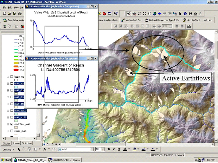 Figure 5. Earthflows can drive significant spatial variability in both valley widths and channel gradients.
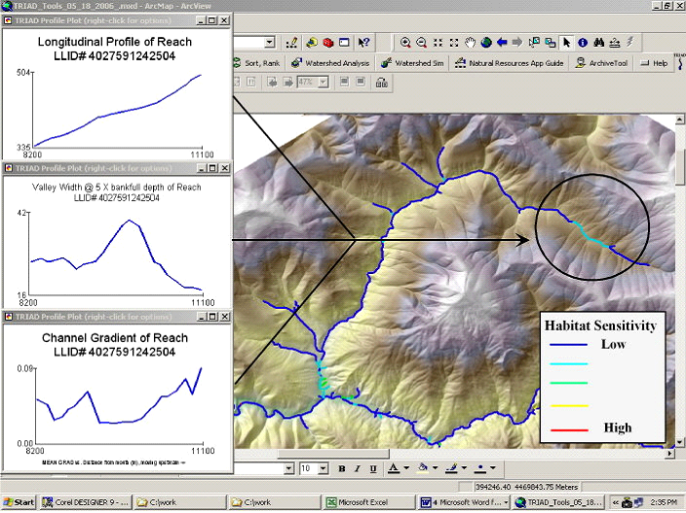 Figure 6. Local changes in channel base level, valley widths, and channel gradients can be used to identify earthflows.
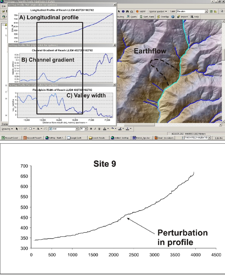 Figure 7. A landslide feature can be identified based on variation in elevation profile, channel gradient and valley width. The bump in the profile corresponds to both an increase in channel gradient followed by (upstream) a marked decrease of gradient.
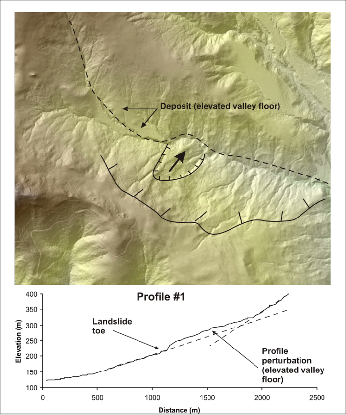 Figure 8. A deep-seated landslide (embedded within a larger landslide complex) in the Mattole River basin in NW California is related to a pronounced bulge in the elevation profile of the channel-valley floor. The smooth looking deposits upstream of the bulge are formed either by alluvial processes, or by an earthflow, or some combination of the two. The channel upstream of the slide is incised about 10 meters into the deposit.
Large and ancient landslides, earthflows, and rockfalls can be considered either as a threat to aquatic resources or as a source of habitat formation depending upon ecological perspective. Because large landslides occur relatively infrequently, the majority of such features in a watershed should be old and hence could be viewed as sources of physical heterogeneity in rivers by creating knick points that reduce valley gradient upstream and increase gradients downstream (Grant and Swanson 1995, Cruden and Thomson 1997). Lower-gradient valley segments upstream of large slides can create wide valleys containing more floodplains, side channels, and more sediment and woody debris (Figure 1). In landscapes such as the central Oregon Cascade Range, earthflows are numerous and important sources of physical heterogeneity in mountain stream channels, including forming local floodplain habitats (Figure 2) (Grant and Swanson 1995).
Large landslides and earthflows also can be considered detrimental to rivers because of increased sedimentation including fine sediment, direct burial of aquatic habitats, and temporary blockages to fish migration. Overall, the morphological consequences of large and ancient landslides, earthflows, rockfalls, and snow avalanches on river channels are poorly understood. The occurrence of large mass wasting features in watersheds can be demarcated on maps, including shaded relief (e.g., Figure 2), although aerial photography and field surveys may be necessary to detect them.
Computer Model
Computer models also can also be used to predict the location of certain types and sizes of earthflows in some landscapes. Roering et al. (2005) describe a method for identifying potential deep-seated-landslide terrain in the central Oregon Coast Range (Tyee Sandstone Formation) from topographic attributes inferred from a 10-m DEM. They found that deep-seated landslides tended to have slope gradients falling between 0.16 and 0.44 and curvature (first derivative of the slope) between –0.008 and +0.008, indicating relatively flat slopes (Figure 9). A 10-m DEM pixel represents only 100 m2 on the ground, whereas deep-seated landslides encompass areas considerably larger. To provide a measure commensurate with deep-seated landslide dimensions, Roering et al. used a spatial averaging technique based on the proportion of pixels within a circular area of radius 250 m that have slope and curvature values that fall within the range indicative of deep-seated landslides. This proportion varies between zero and one, with higher values indicating a greater proportion of the area having topography suggestive of deep-seated landsliding. An example of the model is shown in Figure 5; Roering et al. found that values > 0.33 worked well to delineate zones of deep-seated landsliding in the Tyee sandston. Whether this technique will work for other areas and rock types, and the appropriate value to use for flagging deep-seated landslide terrain, remain unknown.
The deep-seated algorithm likely over predicts the occurrence of deep-seated landslides and earthflows since it does not evaluate level of activity (i.e., ancient and non active terrain would not be differentiated well from more recent or active landslides) and other types of topography that is of low gradient could get included in the deep-seated designation. In addition, the method can not demarcate fine scale boundaries of deep-seated landsliding because of the algorithm it uses.
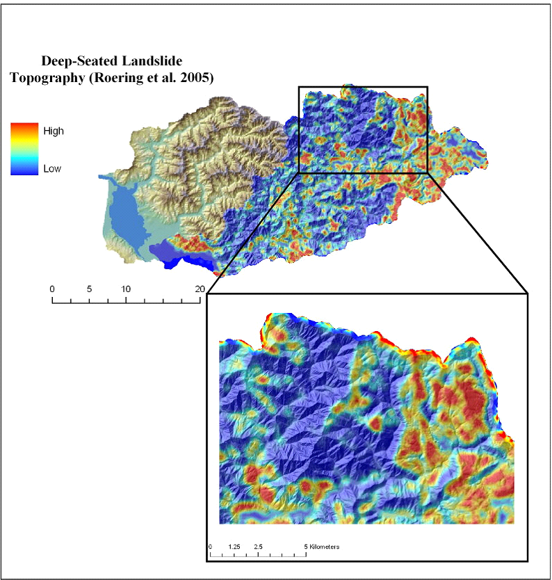 Figure 9. NetMap uses the Roering et al. (2005) model to identify topography that might be associated with deep-seated landslides and earthflows, shown here for the Wilson River basin in coastal Oregon. High (red) values indicate topography that might be indicative of landslide terrain.
|