| < Previous page | Next page > |
Channel SinuosityChannel Sinuosity
Parameter Description: Channel sinuosity, the measure of deviation of a channel between two points from the shortest possible path is calculated as the ratio of actual channel path length divided by shortest path length (Figure 1).
Data Type: Line (stream layer)
Field Name: Sinuosity; Common Name: Channel Sinuosity
Units: L/L, dimensionless
NetMap Module/Tool: Fluvial Processes/Channel Sinuosity
Model Description:
In NetMap, a user selects the multiple of channel widths to define the length scale of the channel segment over which to calculate sinuosity; thus the channel length over which channel sinuosity is estimated is scale dependent and varies with location in the basin (Figure 2). For example, 30 channel widths is the channel segment scale recommended in the Rosgen stream classification system (Rosgen 1996).
Channel sinuosity can only be roughly approximated using synthetic streams derived from digital elevation models. Field measurements are required to more accurately define channel sinuosity.
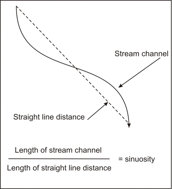 Figure 1. Channel sinuosity is calculated by dividing the length of the stream channel by the straight line distance between the end points of the selected channel reach.
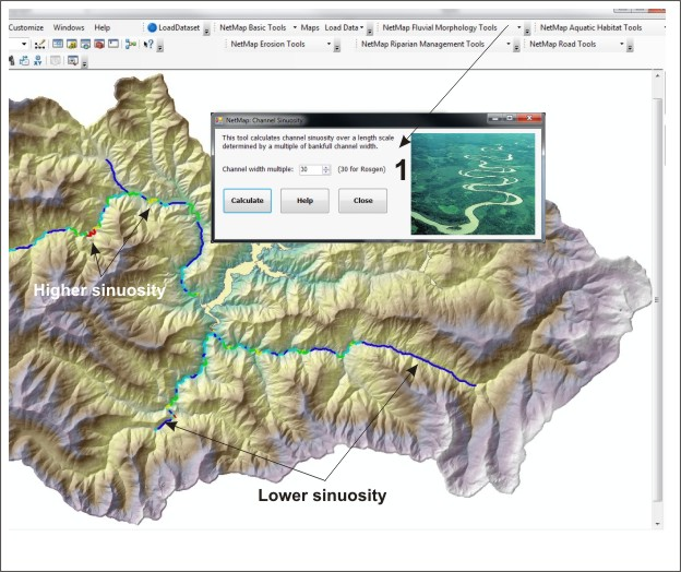 Figure 2. NetMap’s sinuosity tool is located in the ‘Fluvial Morphology Module’. Sinuosity is the length of the channel divided by the straight line distance between the channel end points (Figure 1). Because sinuosity in NetMap is calculated using a DEM, users can consider it a coarse grained or macro scale calculation of sinuosity (e.g., controlled by major valley structure like permanent meanders and lithologic controls [ridges]).
Technical Background:
Channel sinuosity is an important component of fluvial geomorphology and of aquatic ecology. In general, sinuosity is highest in meandering gravel or sand bedded streams and lowest in confined mountain streams. Channel sinuosity arises from flow hydraulic processes around bends in which secondary, across-channel circulation can increase meander wavelength and the migration of meanders across a floodplain (Leopold et al. 1964). Sinuosity can also be “forced” by bedrock outcrops, sediment deposits and log jams, mainly in smaller and steeper mountain streams.
Channels with high sinuosity may have more and deeper pools at the apex of a meander bend compared to straighter channels. Thus channel sinuosity is an important component of fish habitat and the sinuosity parameter could be used within habitat models in NetMap (see Aquatic Habitat Module). Channel sinuosity is also a component of the Rosgen stream classification system (also included within NetMap). However, since channel sinuosity is derived from the routed stream layer built from digital elevation data, it provides only an approximate estimate of the true channel sinuosity. Predicted sinuosity will be sensitive to the scale of the DEM, with sub-meter LiDAR being the best and most accurate data source. Predicted channel sinuosity is likely underestimated and also under represented. Nevertheless, NetMap’s sinuosity tool can provide a relative ranking of where channel sinuosity may be highest at the watershed scale. Channel sinuosity is estimated most accurately from aerial photography and in the field.
|