| < Previous page | Next page > |
4.1 Define Fish DistributionDEFINE Fish Bearing Network (note, this tool resides under the "Analysis Tool" Tab in NetMap)
Parameter Description: The spatial extent of the fish bearing network for either anadromous or resident fish.
Data Type: Line (stream layer)
Field Name: FISH; Common Name: Fish-Bearing
Units: 1 = fish, 0 = no fish
NetMap Tool/Module: Analysis Tools/Define Fish Distribution
Model Description:
A fish-bearing network should be defined before proceeding with a NetMap analysis; fish bearing networks are species specific. The fish network is sensitive to the locations of gradient barriers and it involves setting the available network for anadromous fish below any gradient barrier while allowing resident fish above gradient barriers.
The fish-bearing network is defined by gradient thresholds. For anadromous fish, a migration-blocking gradient barrier is defined, e.g., all channel reaches in excess of say 10% are excluded from the “fish bearing network”. The parameter created is referred to as “fish” (Figure 1) and it can be displayed using the Map Generator. The user references this attribute to specific fish species in the tool.
Referencing Figure 1, the tool ‘Define Fish Distribution’ allows a user to define the spatial extent of anadromous fish (gradient-migration barriers) or resident fish (gradient thresholds, non continuous) (Figure s 1-3). The user should keep records on specific gradient and flow attributes that pertain to any fish distribution. A user may still wish to create other fish-bearing networks using the tool and they can recall the custom fish-bearing network.
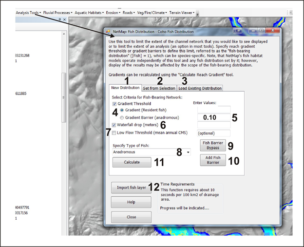 Figure 1. In NetMap, the river network is divided into “fish bearing” and “non fish bearing” channels, a distinction that influences how maps are displayed and how other NetMap analyses are conducted. Users should define the species-specific fish distribution prior to conducting other NetMap analyses. During an analysis when switching from one species to another (e.g., coho to resident fish) the user should change the fish distribution using this tool. When setting a new fish distribution, users select from four options: (1) setting a new fish distribution, (2) setting a fish distribution using a selection of reaches (e.g., selected reaches = fish bearing, non selected reaches = non fish bearing), (3) re-setting an existing fish distribution, and (12) setting a fish distribution using another, non NetMap, stream layer (such as an agency GIS fish layer).
When setting a fish distribution (1), gradient and or flow and or waterfall barriers are defined (4 - 7); if water fall barriers are used, an analyst needs to calculate them first using another NetMap tool, called Calculate Channel Gradients. A fish species (8) is selected to represent the distribution. Resident fish can have habitat located above specified gradient barriers while anadromous fish cannot have habitat located above specified gradient barriers. Fish barriers, such as dams that have fish ladders, can be bypassed (9). Or fish barriers can be added to individual reaches (10). Users may import their own fish layer (12).
 Figure 2. (Top) Users can bypass fish barriers (high gradients). Channel gradients can be displayed (1). The selection tool is loaded and only ONE reach can be selected (2). A new (lower) gradient is input (3) and the gradient is updated (4). All downstream gradient attributes (called max grad D) must be updated (5).
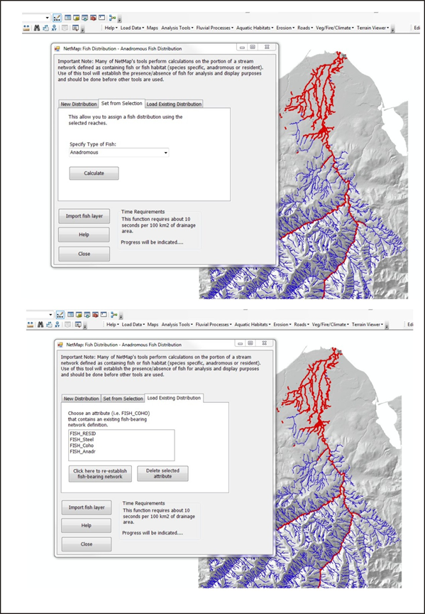 Figure 3. (Top) A user can define the fish distribution for a selected set of channels or a existing fish distribution can be loaded (bottom).
Technical Background:
In NetMap, the tools can be used to match the fish distribution for anadromous habitats that is contained in the "streamnet" mapping (for confirmed fish bearing streams). However, the distribution can be extended beyond that to all streams and rivers that are potential habitats based on gradient and flow thresholds in the intrinsic potential model, including those systems where fish are extinct or extirpated. In this approach, all channels that might have been accessible, but are no longer, can be included in a NetMap analysis. For source data, see: http://www.streamnet.org/mapping_apps.cfm
 Figure 4. Streamnet distribution in the lower 48 states for coho and Chinook, combined (left panel) and steelhead (right panel).
|