| < Previous page | Next page > |
Reach (channel) GradientReach Gradient
Parameter Description: Channel gradient (rise/run, m/m).
Data Type: Line (stream layer)
Field Name: GRADIENT; Common name: Reach gradient
Units: m/m
NetMap Module/Tool: Fluvial Processes/Network Variables
Model Description
Reach gradient is calculated from digital elevation models (commonly 10-m DEMs) at the scale of channel segments (20 – 200 m). The DEM-inferred gradient using the DEM-delineated flow path uses a nine-point surface polynomial as described by Zevenbergen and Thorne (1987). Note that the word “channel” in NetMap can refer to a specific method of delineating linked sets of stream reaches. The default channel gradient calculation in NetMap uses a dynamic window length that ranges from 500 m in lower, less steep areas of valleys (~0.001) to 50 m in the steeper portions of valleys (~0.20). See NetMap's Calculate Channel Gradient tool to recalculate channel gradients over any length scale, including the ability to search for waterfall barriers.
Variation in channel (Figure 1) is important in habitat indices, channel classification, stream power, channel sedimentation, and channel disturbance zones, among other watershed attributes.
Technical Background
Reach gradient is calculated from digital elevation models (commonly 10-m DEMs) at the scale of channel segments (20 – 200 m) in NetMap and the variation in gradients across a watershed is important in numerous tools in the tool kit (Figure 1). Uses of reach gradient in NetMap include creating habitat indices, channel classification, stream power, channel sedimentation, and channel disturbance zones, among others.
Gradient is calculated over a specified length scale; rise over run, with the “run” defined in the River Builder input file. NetMap fits a 2nd-order polynomial over a specified length and determines the first derivative at the center point. The order of the polynomial and the length scale are both specified in the River Builder input file. The gradient is calculated for each point or node (scale based on the DEM used, commonly 10 m). All of the point values are averaged to derive a slope gradient for the reach, which may have lengths of 50 to 200 m (segment lengths are specified in the River Builder input file).
The length scale over which gradient is calculated has important implications. Consider fish passage barriers (for example, an 8% gradient for salmonids). A short section of 8% channel gradient (say 10 m) might be surmountable for fish passage. However, if the 8% gradient went on for a couple of hundred meters, that might pose a fish barrier. Thus, in NetMap, a length scale of 250 m is often used to account for fish barriers (an adjustable parameter in the River Builder).
However, stream segments in NetMap may exceed 250 m. So when determining upstream fish extent based on gradient, the parameters of “maximum downstream gradient” is used, and that is based on gradient calculated over 250 meters.
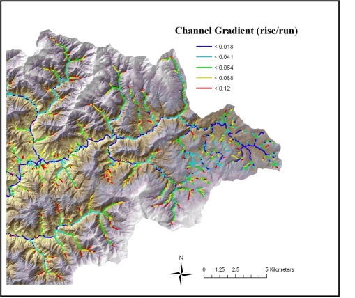 Figure 1. NetMap is used to calculate channel gradient across the channel network.
|