| < Previous page | Next page > |
Comparison of the NHD to NetMap's stream layerComparison of the NHD to NetMap’s stream layer
NetMap’s stream layer is derived from digital elevation models that can range from the National Elevation Dataset (NED, in 10 m resolution) to 1-5 meter LiDAR. In some areas, such as in Alaska, available DEMs range from the SRTM (Shuttle Radar) 30 m to proprietary 20 m DEMs (derived from satellite imagery). The 10-m NED DEM is derived from 1:24,000 scale U.S.G.S. topographic maps (http://ned.usgs.gov/).
The section covers a comparison of the NHD to NetMap’s stream layer.
There can be significant variation in the density of mapped streams. See examples in Figure 1 in Washington and Oregon (NHD+ downloaded 2012).
 Figure 1. (Top) An example from western Washington that illustrates the inherent variation in stream densities in the NHD based on ownership. (Bottom) Another example showing variation in stream density in northwest Oregon.
In addition to inconsistencies in drainage density, there are also considerable mapping errors in certain areas because of the human digitizing factor of NHD creation (in particular headwater streams). Because of dense vegetation or other confounding factors, NHD stream lines, particularly in headwaters can be inconsistent with the actual topography (Figure 2). The inconsistency between the NHD lines (in some areas) and the digital elevation model, suggests that the “burning” in of the NHD into the NED could lead to some undesirable outcomes. However, the NHD should be considerably more accurate in larger channels where it is more clear how the channel relates to the topography (note – NetMap’s uses the NHD as a guide (match) to define the locations of the larger, lower gradient channels in its stream layer).
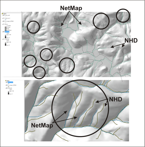 Figure 2. The two panels show examples of NHD flow line inaccuracies compared to the NED (10 m) digital elevation model. NetMap’s stream lines are shown for comparison.
In meandering or braiding channels in wide valley floors, it is difficult to create accurate stream line locations in the NHD because of dynamic channel shifting (Figure 3). This is a difficult problem to overcome in both the NHD and in NetMap’s stream layer that utilizes the NHD in those areas. However, specific users can adjust the stream lines to make them more accurate in their own databases (Figure 4)
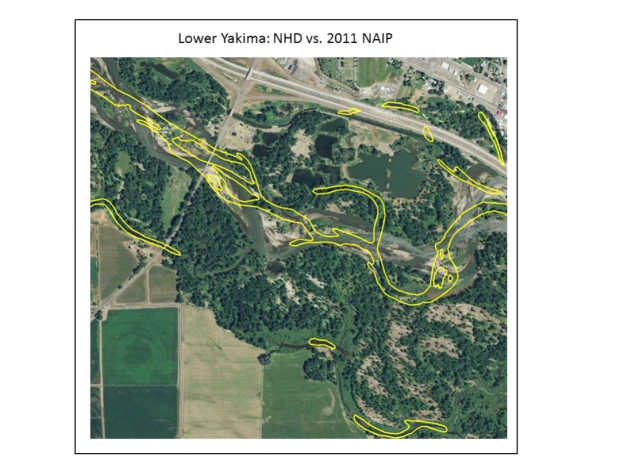 Figure 3. An example of inaccurate NHD double banked streams in the Lower Yakima River, Washington. This type of problems is difficult to address in both the NHD and in NetMap’s stream layer (that uses the NHD in these areas as a mask) because of dynamic channel shifting from year to year due to floods.
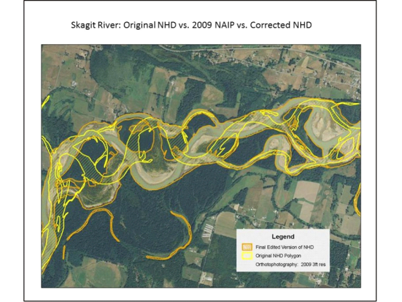 Figure 4. NHD flow lines can be spatially offset from the actual stream channel either due to human mapping error or because of channel shifting over time. Such errors can be rectified by users in specific applications as shown above.
Both the NHD and the NetMap stream layer have important characteristics. Table 1 presents a comparative analysis of the two layers.
Table 1. A comparison between NHD and NetMap
The NHD+ is a valuable data resource. NetMap uses the NHD to guide the locations of channels in areas of low relief and low gradient. NetMap can add value to and strengthen the NHD via attribute transfer.
|