| < Previous page | Next page > |
Fire Effects on Shade-ThermalPost Fire Impacts on Shade-Thermal Energy
Parameter Description: This NetMap parameter predicts the changed stream shading due to wildfire, either in a pre-wildfire or post-wildfire planning mode. Using NetMap's tool for predicting current shade effects on thermal energy in streams, shade is reduced in a post fire environment to identify those locations where shade reductions (and consequent increases in stream thermal energy) are predicted to be the greatest. Overlaying this information with critical fish habitats could be used to prioritize mitigation efforts, including fuels reduction etc.
NetMap typically uses forecasts from the Flammap fire model, with predictions in flame lengths. When using actual burn severity ratings (no fire, low, moderate and high severity) from Burn Area Reflectance Classification (BARC) maps, low, moderate and high severity correspond to flame lengths of low (<= 4ft), moderate (4 – 8 ft), and high (> 8 ft) fire severities or two grids representing low (<= 8 ft) and high (> 8 ft) fire severities (based on Hessberg et al. 2005, http://www.fs.fed.us/pnw/pubs/journals/pnw_2005_hessburg002.pdf).
Learn more about how NetMap can be used in a pre-wildfire planning or post-wildfire planning, using this tool, among others.
Data Type: Line stream layer)
(1) Field Name: SolshdF (Reach layer); Common Name: Solar Radiation: Post fire shade.
(2) Field Name: SolFireDif (Reach layer); Common Name: Solar Radiation: Difference Pre and Post Fire
(3) Field Name: SolarDif_R (Reach layer); Common Name: Solar Radiation: Difference Aggregated
Units: watt-hours/m2
NetMap Module/Tool: Riparian (but only in those datasets where the post fire condition was simulated)
Model Description:
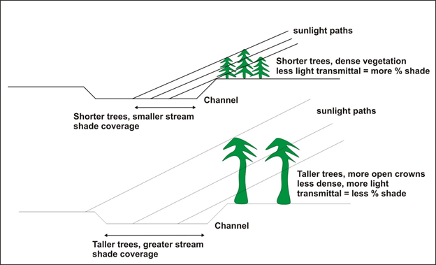 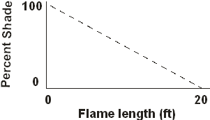 Figures 1 and 2. Left - NetMap's shade model that uses tree height and basal area (Groom et al. 2011). Right - The shade is reduced to a percentage based on a simple linear relationship between shade and flame length (flame length is a pre-fire environment can be obtained from models such as Flammap; flamelength can be assigned to the three classes of burn severity (low, moderate, high) using Burned Area Reflectance Classification (BARC) maps.
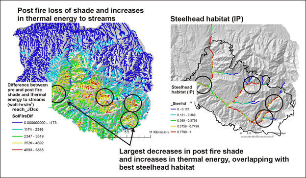 Figure 3. Calculate the difference between pre and post fire shade and thermal energy to streams. The locations with the highest predicted losses of shade and corresponding increases in thermal energy can be overlaid with sensitive fish habitats, identifying those areas where pre fire or even post fire migitation might be appropriate.
|