TODO: To change the footer's content go to Dr.Explain menu Options : Project Settings : HTML (CHM) Export : Setup HTML Template and Layout
Debris Flow Potential
Figure 1. Photographs of debris flows in the Pacific Northwest. (A) Post fire debris flows originating from steep and convergent areas (e.g., Figure 3-2) and traveling through headwater streams in western Oregon. (B) A debris flow in a logged area in northwest Washington. (C) Debris flow deposit within a larger, fish bearing stream, Oregon Coast Range.
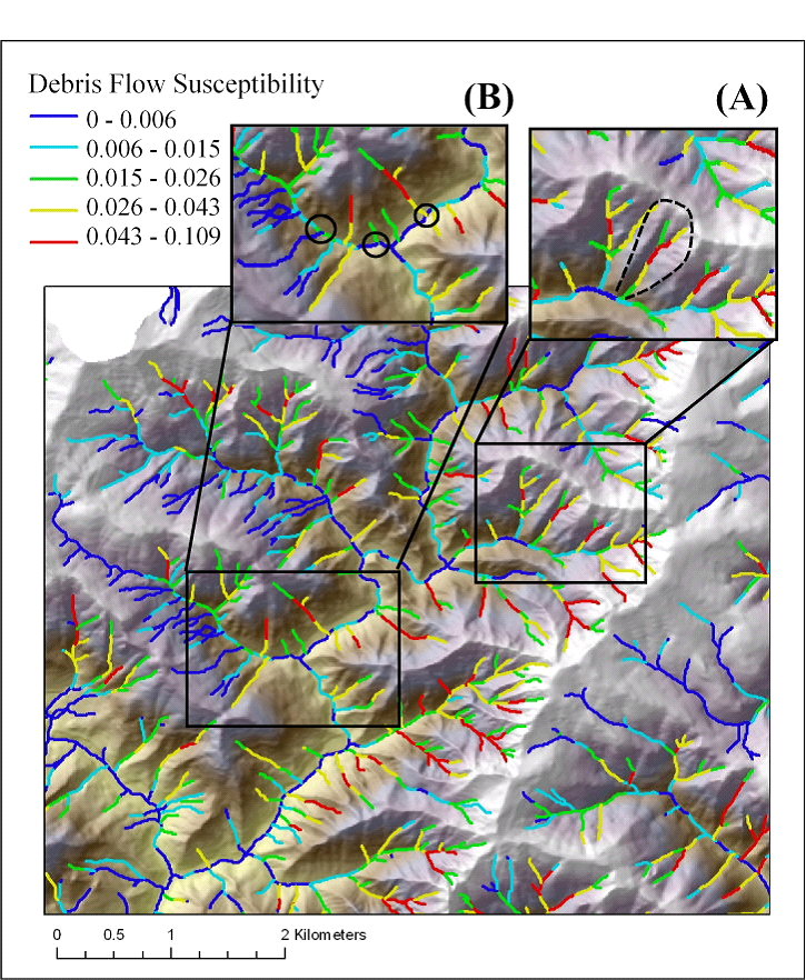
Figure 2. Predicted debris flow susceptibilities are shown for a portion of the Wilson River basin. Downstream sequences of susceptibilities in headwater streams (A) can be used to differentiate one debris flow prone headwater stream from another (low-high might warrant more caution compared to high – low). The susceptibility of headwater streams immediately above a larger, fish bearing channel (B) can also be used to differentiate debris flow potential and possible impacts to larger channels. The downstream sequence of predicted susceptibilities can be used to estimate the likelihood of debris flows reaching a specified channel segment, such as fish habitat. For example, a headwater - upstream to downstream sequence debris flow susceptibility of low – high – low would be less of a concern compared to the sequence of low – moderate – high or moderate – high or simply overall high (A). In addition, one should focus on the predicted debris flow susceptibility of the segment located immediately upstream of the low- to high-order debris flow prone confluence. Headwater segments with high susceptibility immediately upstream of the confluence with a larger fish-bearing stream is of more concern compared to headwater segments with a lower susceptibility ( B).
Debris Flow Impacts to Fish Bearing Streams
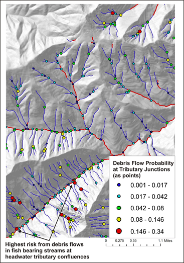
To consider the effects of debris flows on channel morphology or in fish bearing streams, a user should focus on the predicted debris flow susceptibility of the segment located immediately upstream of the headwater-mainstem tributary confluence (in the headwater debris flow prone channel). Headwater segments with high susceptibility immediately upstream of the confluence with a larger fish-bearing stream is of more concern compared to headwater segments with a lower susceptibility.
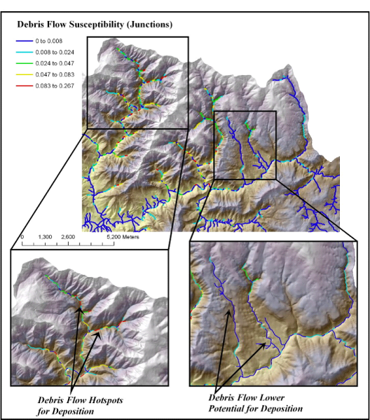
NetMap contains a parameter to facilitate the analysis of patterns (juxtapositions) of headwater confluences prone to debris flows with fish bearing streams. The parameter Debris Flow Susceptibility - Junctions can be used to quickly identify confluences and hence associated fish habitat reaches at potential risk. The debris flow susceptibility-junction is a field that is mapped in the network (outside of headwater first- and second-order streams) that records the debris flow susceptibility value in the lowest part of the confluencing headwater channel. Debris flow susceptibility-junctions are mapped as a reach parameter (so that it can be used in several of NetMap’s tools, including Habitat Diversity and Channel Disturbance. Thus, the point of interest is the area at and in the immediate vicinity of the confluence of the headwater channel with the mainstem stream. In mainstem reaches that have more than one confluencing debris flow-prone headwater channel, the highest debris flow susceptibility value (from the lower most reach of the headwater channel) is reported in the reach file.
Figure 3. “Debris flow susceptibility-junctions” is predicted for tributary confluences in a portion of the Wilson River basin (Oregon Coast Range). This type of prediction will facilitate comparison of debris flow susceptibility with other channel and habitat parameters (see Overlap Risk Tool).
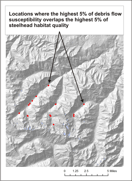
Figure 4. An example of how the attribute "DF_Junct" or Debris Flow Susceptibility-Junctions can be used in NetMap Risk Analysis Tool to determine if and where debris flows overlap sensitive fish habitats. Shown are locations in a watershed in coastal Washington where the highest 5% of debris flow risk overlap the highest 5% of steelhead habitat quality.