Why use linked nodes (instead of, say, a routed vector
network)?
•Data stored at
the spatial grain of the DEM.
•Each node is
associated with a single DEM cell; we can thus initiate flow routing from
any point in the channel network. This helps enable coupling the “digital landscape”
to hydrologic, erosion, and routing models.
•Each DEM cell
can also be associated to a single (or multiple) channel node, so that
areas within a water mask, on the flood plain, and on hillslopes can be associated
with specific locations along the center-line flow path defined by the nodes.
•Node-based
information can be summarized at any larger spatial scale to generate
GIS vector files.
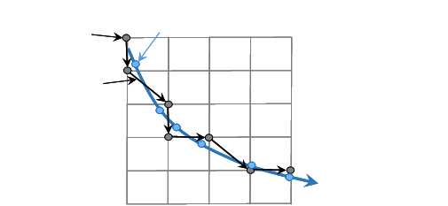
DEM cells
DEM grid point
Smoothed flow
path
D-8 flow path
Channel
node